5.1 Bytown and Prescott - New
Edinburgh
The first
enginehouse in Ottawa was that built by the Bytown and Prescott Railway
at the opening of the line in 1854. It was situated just to the
east of the Rideau River and is shown on the Historical Atlas of
Carleton County of 1879. The enginehouse appears on the Insurance
Company plans into the early 1910 period. The original structure
was destroyed by fire in November 1857, the fire also damaged the,
then, new locomotive Prescott.
14/11/1857
Kingston Weekly British Whig FIRE AT OTTAWA.
The Engine-house
of the Ottawa and Prescott Railway, at this end of the line, was
early on Sunday last consumed by fire, and a new engine and its
tender almost completely destroyed. This engine had been running only
a few days on the road, and it is said to have cost about £3,000. We
have not heard that the cause of the fire has been satisfactorily
ascertained. It is said that the watchman, whose duty it was to look
after the building that was burned and its contents, was, at the time
the fire broke out, either absent, or asleep. A contemporary contains
some very mysterious hints, which would lead it to be supposed that
the fire was the work of an incendiary, and that the watchman was
guilty of some complicity therewith. - If any substantial ground
exist for such a suspicion every possible exertion should be used to
ferret out the truth, and to bring the criminal, or criminals, to the
bar of justice. Appearances would indicate that incendiarism has been
rife, during the last few months, within the limits of the city, and
the interests of the community demand that the most stringent
measures should be taken to deter from its repetition. It is possible
after all, that the destruction of the engine-house and engine is a
casualty that might have been prevented if the railroad watchman had
been as attentive to his duty as he appears, by the statement of our
contemporary, to have been remiss. The destruction of the engine will
be a serious inconvenience as well as a pecuniary loss, to the
unfortunate Railroad Company.
18/11/1857
Montreal Gazette
Between Saturday
night and Sunday morning last, the engine shed of the Ottawa and
Prescott Railway Company, at this city, was burned to the ground. The
beautiful new locomotive "Prescott", lately purchased by
the Company, was in the shed at the time, and was, of course, much
injured ; It is estimated that it will cost about $1,000 to repair
the damage. The shed itself was of little value. The fire was
first discovered by Mr. Baskervllle, the watchman at the terminus,
about half a mile distant from the shed. He, of course,
could not leave his post, but quickly roused some persons in the
neighbourhood, who hurried to the spot. They found the shed all in
flames, so that the locomotive could not be removed, but were in time
to remove some cars which otherwise would have been destroyed. The
watchman was found asleep in one of the cars. He immediately
absconded and has since kept out of the way. Rumours are afloat that
the fire was the work of an incendiary, but nothing has yet
transpired to cast suspicion on any one. It appears quite possible
that the culpable negligence of the watchman is alone to blame.
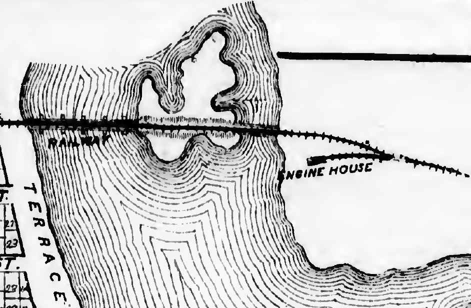
This is the 1879 Belden map
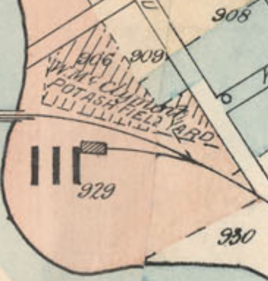
The
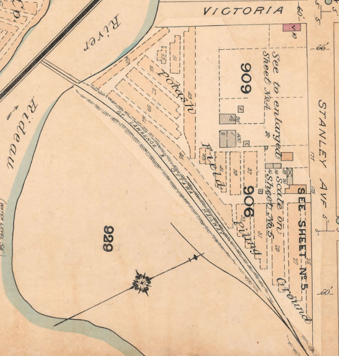
1888 FIP Key Plan also shows the spur and rectangular enginehouse
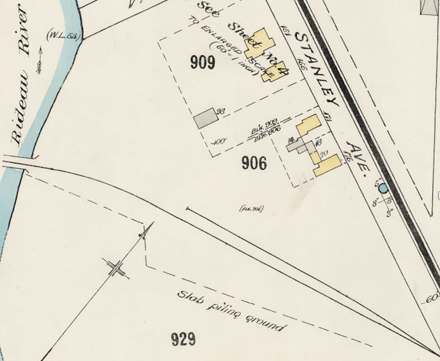
This insurance sheet dated
1895, shows the spur with no enginehouse
The
1912 plan does not show the spur, but it does show the property line
diverging south from the mainline to accommodate the spur and
turntable, but it then bends north before the bridge.
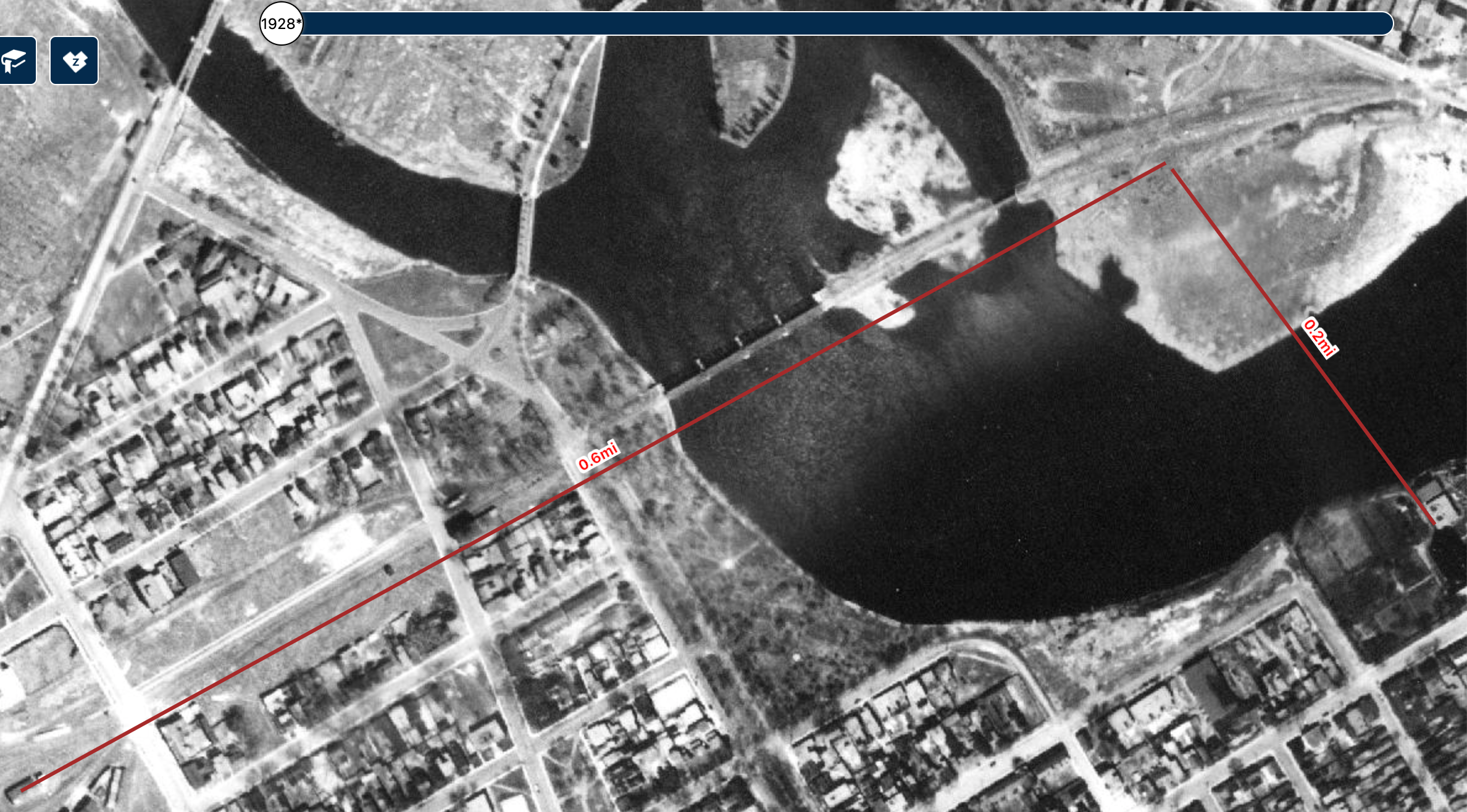
On
the 1928 GeoOttawa air photo, the location of the engine house was
0.6 miles "about half a mile" from the Sussex
Street Station. The watchman could have had a clear view to the fire
down the line."King street" was King
Edward Avenue, which then continued straight to cross McTaggart
Street at the west end of the railway bridge.The "nunnery" would have
been the Good Shepherd Convent, 0.2 miles directly across the Rideau
River "opposite" the roundhouse. It was already there by
1869 as a 3-storey frame building, replaced by the stone building in
1875 which is now the Chinese Embassy.
5.1A St. Lawrence
and Ottawa - Chaudiere
Ottawa Free Press, 10/16/1871. "The contract for building the
Chaudiere engine house has been given to Mr. Palen."
In
the summer of 2016 the site of the St. Lawrence and Ottawa Railway
Roundhouse and turntable pit was excavated by a team of archaeologists.
Remarkable Stone Ruins of 19th Century Railway Roundhouse Unearthed at City Centre
5.2
Canada Atlantic - Elgin Street
The
roundhouse is
shown on the 1888 Insurance company plans and is labelled as the Canada
Atlantic Railway Engineers Shop. It was on the south side of Archibald
St.(Arlington) just west of John St. (now Cartier). This
is now the site of the apartment building north of the Queensway on the
Driveway. The turntable was about 50 feet
diameter and the roundhouse was
about 55 feet deep. It covered an arc of just over
120 degrees. There was a small 2.5 story office building next to
the roundhouse, which appears in a photo in John Trinnell's book.
--
Railway and Shipping World, July 1899, p209
The Canada Atlantic will
this
fall commence the erection of large car shops at Ottawa in addition to
those already put up. The new shops will be located near the
Rideau roundhouse, where the machine shops & repair works are
situated. The buildings put up this spring at the foot of
Elgin st. & which are now being used, will be discarded after the
proposed structure at Ottawa East is up. They will then be used
by the Co. for storage or may be available for manufacturing
purposes. When the new car shops, which will be erected &
equipped at a heavy cost, are completed, all the works of the Co. will
be adjacent to each other, instead of being 1/2 mile apart as at
present. They will consist of erecting, woodworking, drying &
painting shops, & will run by electricity. In order to make a
foundation a great deal of filling in will have to be done, & work
on this will commence in the near future in time for the erection of
the shops to start in Nov. & be completed early in the spring.
The CAR
Elgin
Street Shops were destroyed by fire in April 1902 burning 2
passenger cars, 1 combination car, 2 freight cars and 1 wrecking
derrick.
5.3 Canadian Pacific - Ottawa East or
Riverside
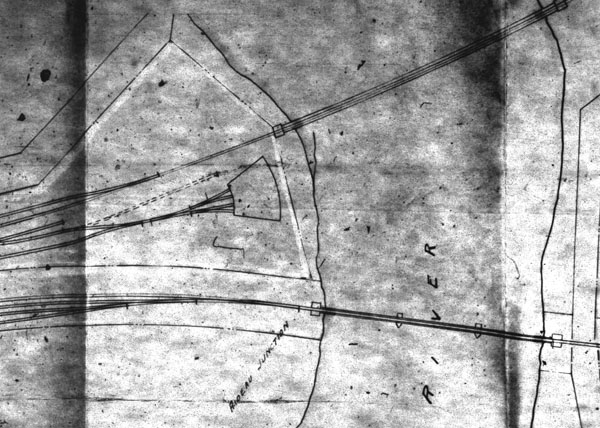
This diagram is taken from a Grand Trunk
Railway blueprint dated March 1915. It shows the two bridges across the
Rideau River, CPR to the north, top, as well as the CPR four track
roundhouse.
It appears from this diagram that the roundhouse did not have a
turntable .
The Canadian Pacific roundhouse at
Ottawa
East was constructed in
September and October 1899. The Ottawa Free Press of 26 September
1899 shows:
The Canadian Pacific railway has
commenced the erection of a round house
at Hurdman's bridge. It will be located between the C.P.R. and
the
C.A.R. bridges and will have four tracks leading into it.
The Railway and Shipping World for
November 1899, page 324 mentions the Canadian Pacific roundhouse
at Hurdman's Bridge, Ottawa.
Until the opening of this
roundhouse CPR
locomotives were handled at the Canada Atlantic round house at Ottawa
East as explained in the Ottawa Citizen account of the first day of
operation 5 September 1898 which was published on 6 September 1898.
By special arrangement with the C.P.R. these engines and all
others
connected with the manipulating of the traffic
will be installed in the roundhouse at Ottawa East.
The Ottawa Journal of 10 September
1906
contains the following:
Engine backs
through a wall
Is now on rocks back of roundhouse.
At the Rideau round house of the
Candian Pacific railway at Hurdman's Bridge, this morning an engine
broke through the back of her stall and almost into the water.
The round house is slightly elevated to bring it on a level with the
main line tracks and the big engine fell a few feet. She
is sitting upright on the rocks and the wrecking crew is jacking her up
to put rails under her. The accident happened about 7
a.m. The men had lighted her fires and not noticed that the
throttle was slightly open and the lever set off the centre. When
steam accumulated it found its way into the cylinders and the
engine backed up, plunging through the rear wall. The steam
failed before she reached the water.
On Tuesday September 11 there was a follow up.
Engine
again on
track
There was a gang of men working
all
day yesterday and all last night at the C.P.R. Rideau Round House,
where engine 209, used on the short line, had broken through the back
of the round house and almost stood on end on the bank of the
river. The engine was again on the tracks. Engineer Ingram,
who was in charge of the engine, could not stop it on the incline into
the round house.
In April 1910 CPR was asked at a
hearing
of the Board of Railway Commissioners about locomotives for the
M&O service to Montreal. The reply was "the engine goes into
a house near the Ottawa & New York. We have a small engine
house there in which we can get one engine in. We have three
stalls but we can get only one engine in on account
of the larger power we are using now."
By 1912 people living in the area
were
complaining about smoke drifting over their homes.
A Grand Trunk Railway plan dated
March
1915, which was produced to show a proposed interchange with the
Canadian Northern Ontario, shows a four track roundhouse at this
location but, curiously, it shows access via switches and not a
turntable.
The 1917 CPR
condensed plan and profile shows a small roundhouse situated between
the CPR M&O and the GTR Alexandria lines immediately to the west of
the Rideau River at Hurdman close to the CNR
Riverside location where the single track across the
Rideau River became double track into Ottawa Union station.
Signs of the pits etc. can be seen
on
early air photos although the building had gone by the mid-1920s. This 1945 air photo was supplied by Malcolm Vant 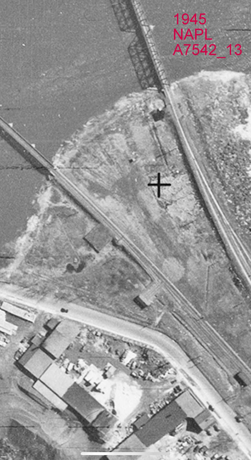
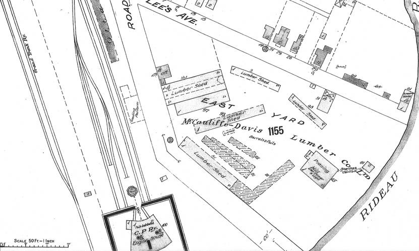
Image provided by Malcolm Vant from http://history.ottawaeast.ca/railways.htm
5.4 Canadian Northern
Ontario - Federal
References:
- Canadian Railway and Marine World in January 1914.
- Peter Lange wrote an article in the August 1980 Branchline
which used the above as a basis but included some good diagrams. http://www.bytownrailwaysociety.ca/phocadownload/branchline/1980/1980-07-08.pdf
- Bruce Ballantyne prepared a follow up article in the October 1980
Branchline. http://www.bytownrailwaysociety.ca/phocadownload/branchline/1980/1980-10.pdf
The Canadian Northern had very
grandiose
plans for this area which
included a new town to be built in the neighbourhood. This
facility was opened with the opening of the CNOR line to Smiths Falls
in 1913 but was abandoned about 1922 when the CNOR was integrated
into CNR with locomotive servicing being done at Mann Avenue and
with freight being handled in the Bank Street yards.
The following information was
abstracted
from a November 1918
Canadian Northern plan filed with the Board of Railway Commissioners as
'Completed Railway Plan 563'. Dimensional data is generally
scaled from the plans, but in a few cases it has been calculated from
the plan chainage.
The facilities at this point, named
'Rideau Yard', were situated
entirely on land owned by 'CN (Canadian
Northern) Town
Properties'. Rideau Jct., the point of connection between the
Toronto-Ottawa Line and the Ottawa-French River Line, was at mileage
244.67 from Toronto. The Toronto-Ottawa and Ottawa-French River
lines were also joined by a 4,100' connecting track that began about
5,300' and about 4,600' west of Rideau Jct. on the Toronto-Ottawa and
Ottawa-French River lines, respectively.
Rideau Yard was located entirely
within
the triangle bounded by
these three
tracks. On the Ottawa-Toronto side, there was a four-track,
double-ended yard whose extreme headblocks were 4,000' apart, the
sidings themselves ranging from about 3,600' down to 3,100'.
On the Ottawa-French River side,
there
was a single double-ended
siding about 3,400' long. The 2,200' long engine terminal lead
ran off the east end of this siding towards the centre of the triangle,
ending at the 90' turntable.
The 13-stall enginehouse was
located in
the northeast quadrant of
the turntable. The second most easterly track was a through track
with a double-length stall. Two outside tracks also radiated from
the turntable, opposite the through track and the westernmost stall.
Another 5,000' of sidings ran off
the
main lead and serviced a
stores building and the coal plant. The water tank, probably
50,000 gallon steel) was completely south of the engine terminal and
likely fed strategically placed standpipes. A bunk house,
boarding house and ice house were located about halfway between Rideau
Jct. and the roundhouse, adjacent to the Ottawa-French River through
siding.
In December 1919 the CNOR was
authorized
to construct a spur
beginning on the Toronto line close to the junction thence in an
easterly direction to the west limit of the Ottawa-Prescott Provincial
Highway into the premises of the Ontario Good Roads Commission.
This siding didn't last too long as the rails had already been removed
by 1931. A spur existed into the Drummond's yard until
recently. It seems tht the bed of the Highways spur was reused,
although not all the way to the road.
The topo sheets and air photos in
the
National Air Photo Library at
615 Booth show the situation in 1931. Air photo series A4413
frames 16 and 17 clearly show the outline of a roundhouse and pit at
that location with a spur from the
east bifurcating Federal. There was also a North/South track to
the west which put the roundhouse in the middle of this big wye.
No other structures (coal tower, watertower, sheds) seem to be
there. There is a string of cars on the spur in to the
pit...probably dead storage. There were about 30 boxcars on the
spur that day. There are two other interesting structures.
One is just to the south of the Smiths Falls sub, maybe a hundred feet
from the Federal switch. Maybe a control tower or station. There
is a larger building on the south
side of the roundhouse spur, perhaps 300 feet from the switch...perhaps
offices for the facility. The faint outline of the siding for the
Ontario Good Roads Commission can just be made out running south of the
main line as far as the highway.
The pictures in 1956 (A15332, frame
142)
are quite similar but
everything is overgrown.
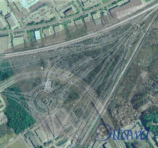
This overlay prepared by Bernie Geiger from
material
from the City of Ottawa and the National Air Photo Library 1999.
To this has been added an overlay of the CNOR
planned track layout taken from Canadian Railway and Marine World Jan.
1914.
Amazingly, this survived in the
forest until the winter of 2007-08 when the area was cleared for
redevelopment.
5.5 Canadian Northern Ontario - Hurdman
The
Canadian
Northern Ontario line from
Hawkesbury was opened on 3 December 1909, some four years ahead of the
line to Toronto. As late as September 1909 the company was still
seeking an entry into Ottawa and consideration was being given to using
the Ottawa and New York Railway engine
house access to which
would have been gained through a transfer track across Hurdman's
Road. In the event there was difficulty in obtaining agreement
for this connection and the company was forced to build its own
facility. A small, two stall, roundhouse was constructed in the
Hurdman/Mann Avenue area west of the Rideau River. The Railway
and Marine World for February 1910 mentions the roundhouse
"The
temporary roundhouse which is being
erected at the foot of Henderson Ave. is expected to be completed early
in Feb. It will accommodate 12 locomotives and will have a repair
shop attached."
It is evident
that
this was not ready for the
commencement of the service to Montreal and
Quebec.
The 1922 fire insurance plan
(PA
NMC 10837 163/263)shows the
2-stall CNoR roundhouse and turntable near the Hurdman terminus. The
turntable is about 530 feet measured from the street centre line,
directly behind number 25 Robinson which runs off Hurdman. It
is about 900 feet northeast of the Hurdman/Robinson intersection, which
is in the same position today as then. There is no indication of
any watering or coaling facility nearby. The turnout for
the turntable faces east about 350 feet from the centre of the
turntable. The south wall of the roundhouse lines up due west
from the centre
of the turntable. The turntable is approxmately 120 feet diameter
and the shed is about 150 feet deep.
This
facility was
used for passenger
locomotives until the amalgamation into CNR allowed use of the Mann
Avenue Roundhouse. A daytime switcher was also allocated here for local
switching and interchange work.
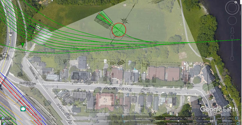 This is developed by Paul Delamere and Malcolm Vant from the 1912 Insurance Plans
5.6
Mann Avenue Roundhouse
In 1896 the OA & PS was
extended to
form a wye with the lines of
the Canada Atlantic Railway. In July of the same year, Booth
filled in 10 acres of land south of Mann Avenue, inside the wye, to
form a new roundhouse and railway shops complex for the OA &
PS. The CAR shops
and roundhouse had been on the west side of the Canal,
The OA&PS roundhouse and shops
of
1896 could well have been
exactly the same buildings that survived there until demolition in
1964. The 10-acre area could have been the entire triangle formed by
the roundhouse, the 40 ft by 170 ft shops building south of it, and the
coal tower 1100 feet or so to the east. The old fire insurance
map, which had clearly not been revised to the 1950's publication date,
showed the roundhouse with a 55-foot turntable, a near full circle of
72-foot stalls, and an extension of three of the stalls on the south
side to 95 feet. (The extension could have had tracks into all
three stalls from the southern approach, without needing to use the
turntable). The turntable was enlarged in later years to about 95
feet, and more stalls were extended. A panoramic photo of about
1915 apears to show the roundhouse as a full circle, with no gap
to the northwest. This gap is evident in a 1933 aerial photo.
Coaling was originally carried out
from a
13 chute coaling
stage and the coal tower appears to have been a later
addition. It is a Grand Trunk standard design and appears in the
1925 picture but not the 1902 picture. There was also a large
building on the southwest side of the roundhouse,
which was there until 1958 or later, though by then the erecting shops
were gone.
The following is from the book
"Enginehouses & Turntables on
Canadian Railways" by Edward Forbes Bush, Boston Mills Press, Copyright
1990, page 63:
"Its walls were of wood
lined
with brick. It numbered 22
stalls for the accomodation of locomotives and 6 for use as a tender
shop, where repairs were made to cisterns, frames and tender trucks.
There were three drop pits , with the machine shop annex opening on two
stalls, one of which was used as the blacksmith's shop. The plan
drawing, revised in 1933, shows the boiler house and stores building as
separate but nearby structures. Heating was by hot air, at least by
1919, according to the GTR report of that year. With its plank flooring
the Ottawa GTR roundhouse does not seem to have been the fore of
roundhouse design."
The book goes on to show the 1933
revised plan of the CNR roundhouse.
The stalls were numbered counter clockwise from the opening to the
north-west. Interestingly, stalls 1-8 were extant as 74' stalls, with
#8 being lengthened to 100'.
Stalls 9-12 were already 88' long at that time, possibly indicating
that these stalls were either previously extended, or were new stalls
added to the original roundhouse at one time. Stalls 13 thru 19 were
lengthened from 74' to 100', and a gap existed between 15 and 16 with
two tracks leading to the cinder pits to the southeast. Stalls 20 thru
27 were still 74' at that time. Stalls 1-7 and 20-27 appear to have NOT
been lengthened due to the proximity of the main lines of the wye to
the rear walls of the house. Also worthy of mention are other stalls
(not numbered) which were used for other purposes. Between stall 1 and
the gap to the northwest was a storage stall. Between the gap and stall
27 there was a carpenters shop. Between stall 16 and the gap to the
southeast there was a stall for the blacksmith. The machine shop
extended off stall 16 and the blacksmith's stall.
David Jeanes wrote on 17 March 2016 "Bush shows the roundhouse in its maximum CN configuration in 1933, with
the erecting shop gone. The fire insurance plans show earlier
configurations, including 1912 where the access to the northwest was
covered, making it a full circle."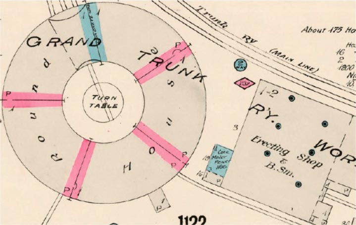 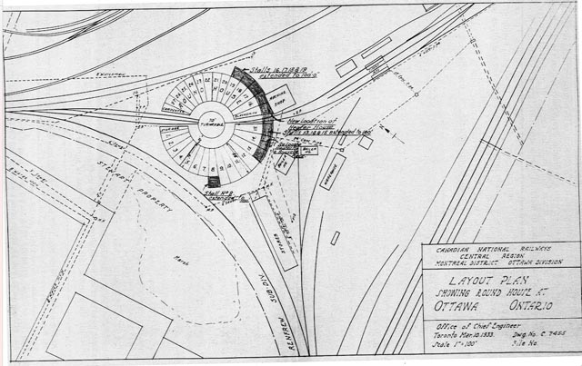
5.7 Canada Central - Ottawa West
The
Canada Central Railway had an enginehouse on the Chaudiere presumably
from the opening of the line in September 1870. However the
earliest reference in the newspapers is:
Ottawa Free
Press, 9/27/1880. "A new turn table is being placed in position
in front of the C.C.R.R. engine house at the Chaudiere. Men were
engaged in this work yesterday."
N.B. This is likely in
connection with the change of gauge from Provincial to standard and the
entry into the Chaudiere by the Quebec, Montreal, Ottawa and Occidental
Railway.
A plan
dated 20
April 1881 (after the Canada
Central gauge change to standard) and prepared by the St. Lawrence and
Ottawa Railway in connection with an application to cross the Canada
Central at Chaudiere shows a three road Canada Central
roundhouse. At this time there was no connection between the St.
Lawrence and Ottawa and the Canada Central. However, the main
track of the Quebec Montreal Ottawa & Occidental Railway from the
Prince of Wales bridge joins the Canada Central. Maybe the QMO&O
used the CCR roundhouse.
Ottawa Citizen, 10/26/1883: Shortly after two o'clock the old
roundhouse situated on the north side of the track, was discovered to
be on fire. Notwithstanding that the fire brigade was promptly on hand,
it was found impossible to save the building, which was totally
destroyed. Fortunately there were no locomotives in at the time,
the last one having been taken out for shunting purposes just before
the fire broke out. The origin of the fire is unknown. The
loss is estimated at about $3,000."
5.8 Canadian Pacific - Ottawa West
The Canadian Pacific had
essentially two enginehouses at Ottawa West.
Ottawa Free Press, 8/24/1883: "The C.P.R. roundhouse at the Union
Station is fast nearing completion."
Ottawa Free Press, 10/5/1883: "The new C.P.R. roundhouse is going up
fast. It is of enormous size."
Ottawa Free Press, 10/22/1883: "The new C.P. Ry. roundhouse will
be finished this month."
Ottawa Citizen, 10/29/1883: "The new CPR roundhouse will, it is
expected, be completed about the 10th of next month."
Ottawa Citizen, 12/13/1883: "The new round house of the Canadian
Pacific Railway Company at the Chaudiere is now completed and affords
accommodation for twenty locomotives and tenders."
Ottawa Free Press, 7/31/1889: "Repairs are being made on the Canadian
Pacific Railway Co.'s round house on the Richmond Road. The old
brick work is being replaced by new material."
Ottawa Journal, April 12 1910 "In one of the most spectacular fires
seen in the vicinity of Ottawa for some time, a section of the C.P.R.
roundhouse was destroyed at about half past three o'clock this morning
and four big mogul engines were damaged beyond repair.
"The first alarm was sounded from box 141 at the end of Wellington
street at 3:40 and when deputy chief Stanford arrived he immediately
sent in a second alarm on account of the great headway that the flames
had made which made it appear as if the destruction of a nearby row of
wooden houses was inevitable.
Much difficulty
"The firemen had great difficulty in getting their apparatus near the
burning building on account of the fact that since the completion of
the new viaduct there has been no provision whatever made for the
entrance of a waggon of any description into the immediate vicinity of
the shops.
--
"On account of the strong wind that was blowing, and the tangle of
scrap iron etc. which the roundhouse contained, the firemen experienced
great difficulty in combatting the flames at first, but when the engine
"Canada" was coupled to two lines of the hose the blaze was brought
under control inside of thirty-five minutes.
Many spectators
"The incessant whistling around emitted from the engines which were in
the burning portion and the lurid flames, attracted many spectators to
the spot, in spite of the early hour, and as the usual custom in such
cases, a squad of policemen were sent up from the station.
"Engines Nos. 42, 206, 274 and 1297 were completely wrecked and their
loss will inconvenience the railroad as they were all in active service.
More.."
Chesterville Record, 4/21/1910: "The CPR roundhouse and three or four
engines at Ottawa were damaged by fire."
4/1911 An Ottawa press report says that a new 16 stall roundhouse
is to be built at Hintonburg west of the present one, a portion of
which was burned down in the summer of 1910. The new building
will be of concrete and will, it is said, be started at once.
Some rearrangement of the yards will also be made ..."
The following is from the book
"Enginehouses & Turntables on
Canadian Railways" by Edward Forbes Bush, Boston Mills Press, Copyright
1990, page 58:
"The CPR's Ottawa West
roundhouse, 21 stall capacity, was
built in 1911 by J.B. Sanderson, an Ottawa Contractor. In 1925 the
machine shop was modernized and in the following year a 6-stall
extension was added. the walls were of reinforced concrete
construction,
as were the columns and beams. The joists on the other hand were of
white pine and B.C. fir."
From David Jeanes, May 2016:5.9
New York Central shops.
The NYC had
a
small locomotive facility adjacent
to, and to the north east of, their passenger station to the west of
Mann Avenue (or Ann Street/Gladstone /Avenue) at the corner of Nicholas
(approximately where the Ottawa University heating plant is today).
The Railway
and
Shipping World, Aug
1901, page 231 reports "Five locomotive stalls will be built at Ottawa
this year, to form the first half of a 10 stall round-house."
The Canadian Northern
Ontario Railway was considering using this facility when it opened
its Hawkesbury to Ottawa line in December 1912. The NYC was
agreeable and prepared to extend its roundhouse to accommodate the
Canadian northern Ontario locomotives. In the end the CNOR could
not get permission, at that time, to cross Hurdman's Road with a
transfer track to the Ottawa and New York yard and the CNOR was forced
to build its own facility at Hurdman.
A picture
is
shown on the cover of Branchline
for April 1982. There was a coal track and a turntable in 1906,
both located further east and just before the junction with the CPR
M&O sub. The turntable is shown on a 1928 aerial photo but
had gone by 1933. The engine shed was replaced in the 1950's by a one
stall concrete structure which survived into the early1960's as a
covered storage bin for road sand and salt.
5.10 Hawkesbury
There were
two
engine houses at Hawkesbury.
A Canadian Northern Ontario Railway
plan
and profile (RG 46 vol
1612 file 9049) of Proposed Crossing of C.N.O.Ry & G.T. Ry Cos
Telegraph Lines at Hawkesbury dated 11 November 1908 shows a four road
roundhouse and turntable south of the CNOR main line and east of the
GTR. It was located in the triangle formed between the two main
lines and the connecting track between the two. This was used
until the 1960's.A 1918 Grand Trunk
Railway plan (RG 12M
78903/47 item 2984) of Hawkesbury shows what would appear to be a one
road engine house in the Grand Trunk (formerly Canada Atlantic) wye
close to the Grand Trunk station.
5.11 Pembroke
A 1918
Grand
Trunk Railway plan (RG 12M 78903/47
item 2995) of Pembroke shows a three track roundhouse in the former
Pembroke Southern Railway yard at Pembroke.
5.12 Gatineau Valley
(Maniwaki) line
The first
section
of line was opened from Hull to
Wakefield in
early 1892 and an enginehouse and turntable was being erected at Wakefield on 21
January that year. No arrangements were initially made for
servicing locomotives at Hull because the details of terminal station
had not been worked out. The first trains were run tender first
one way because of a lack of truning facilities in Hull. It is
believed that arrangements were made to run on to the CPR at Hull and
over the Prince of Wales Bridge into Ottawa where the locomotives would
have been serviced.
The first
train
arrived in Kazabazua on 14
February 1893 and a temporary enginehouse and workshop were in place
for this.
The line was
extended from Wright to Gracefield on 19
October 1895 and a temporary engine
house was in place for the opening. On 25 October that year a
turntable was being moved
from Wright to Gracefield. This raises the likelihood that there
was a temporary engine house at Wright
which would have been used until
the
line was extended to Gracefield. The Gracefield engine house was
in place until to opening of the
line to Maniwaki but it is not known how long it lasted after this.
A two track
engine house was in place at
Maniwaki in time for the opening of the line on 8 February 1904, in
fact it was in place on 30 December 1893. This was retained until
the end of steam.
5.13 Waltham line
The Quebec, Montreal, Ottawa and
Occidental Railway opened from Hull to
Aylmer on 6 August 1879 and a turntable had been installed by that
time. It is not known whether an engine house was also provided.
The Pontiac and Pacific Junction Railway built the section of line from
Aylmer west to Waltham. The first section was opened from Aylmer to Quyon on 6 December 1884 and engine houses
were in place at both Aylmer and Quyon by this time.
The Pontiac Pacific Junction
Railway
established a workshop at Aylmer
which was later used for heavy
repairs for locomotives from the Gatineau Valley line. It was located
near the corner
of Front and Notre Dame streets. It seems it remained until the
take over by the Canadian Pacific Railway in 1902. The above
picture, taken in December 1899, appeared in the Shawville Equity,
from the collection of Carroll Boucher.
An engine house was built at Waltham
for the opening of the line on 2 February 1888 and this lasted until
the end of steam.
The Ottawa Citizen of 16 October 1896 records:
A shunting engine on the P.P.J.
Railway fell into the space
adjoining the company's round table at Waltham yesterday. The
engine was about to be run on to the table but the tracks, not having
been brought even to each other, the engine went down. The engine
was raised again in about five hours. It was not damaged much and
fortunately no one was injured by the accident.
It is also likely that temporary
buildings were erected as the line
was gradually extended between 1884 and 1888 but all details are not known.
The Ottawa Journal of 4 February 1887 records:
A Coulonge correspondent of
the Equity says: The P.P.J. trains make their regular weekly trips,
that is, when it is not too stormy, but now that they have a turn table
here, it is to be hoped they will be able to do better work.
5.14
Brent
The
Canadian
Northern Ontario Railway built a
five stall roundhouse and coaling tower at Brent for the opening of the
line
between Ottawa and North Bay in 1915.
5.15
Quebec, Montreal, Ottawa and Occidental Railway - Hull and Aylmer
The
QMO&O had
an engine house in Hull ready
for the opening
of service in December 1877. The turntable pit was completed on
December 7 and the turntable was installed the next day. The
QMO&O line was extended from Hull to Ottawa over the Prince of
Wales Bridge in December 1880 and from that time trains originated and
terminated in Ottawa so presumably the engine
facilities ceased to have been used around that time.
A turntable
was
being installed at Aylmer on
16
August 1879, shortly after the line had been opened from Hull on 6
August 1879 although it is not known if a locomotive shed was installed
at that
time.
5.16 E.B. Eddy - Hull
The E.B. Eddy company commenced
using two
narrow gauge locomotives
in their mill yard in Hull on 1 May 1888. The former animal
powered rail network had to be rebuilt in order to allow steam
locomotives to
be used. On 13 July the Ottawa Journal noted.
The E.B. Eddy lumber company
have
completed the new round house
for their yard locomotives and have added an addition in the shape of a
commodious coal stage where locomotive coal is stored.
Although the paper mentions a round
house, which inplies access
through a turntable, it is likely that this was just a one or two road
shed. The locomotives were tank engines and would not have
required turning. There is no evidence of a circular house on the
only two known photographs of the Eddy narrow gauge operation:
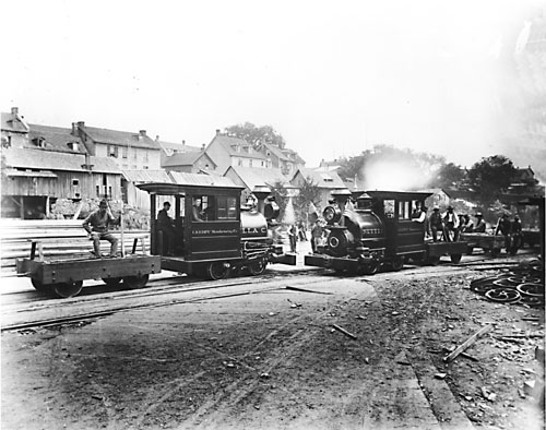
National Archives PA-012446
The first shows the
locomotives evidently in their
original paint scheme and probably on the first day of operation, 1 May
1888.
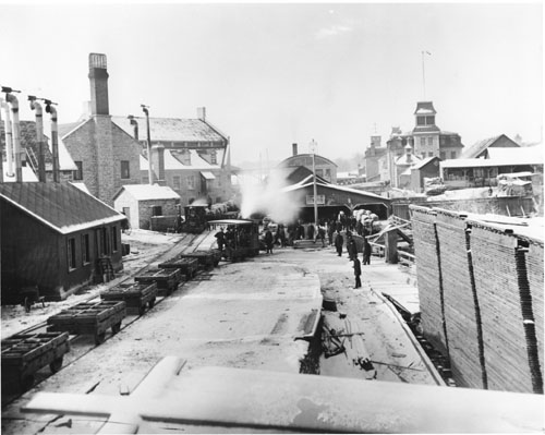
National Archives PA-012442
The second was
likely
taken at a later date after the
locomotives had been in use for some
time.
5.17 Canadian Pacific - Kingston
The turntable was removed and taken to Wakefield, QC. It was installed on 11 July 1974.
See also http://www.kingstonhistoricalsociety.ca/roundhouse.htm
5.18 Brockville and Ottawa Railway Perth
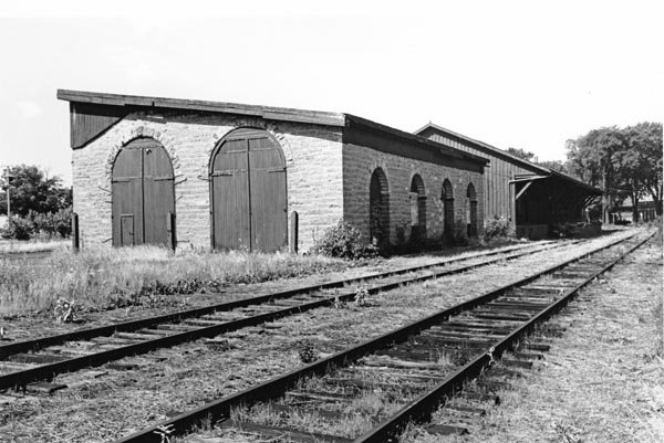 The enginehouse in its later form as a freight shed in 1970. LAC PA 203818 The enginehouse in its later form as a freight shed in 1970. LAC PA 203818
The building was later converted for use as a freight shed and lasted until the mid 1970s. It
appears that an original gable-end roof to the engine house was replaced
with a sloping roof with some alteration to the stonework.
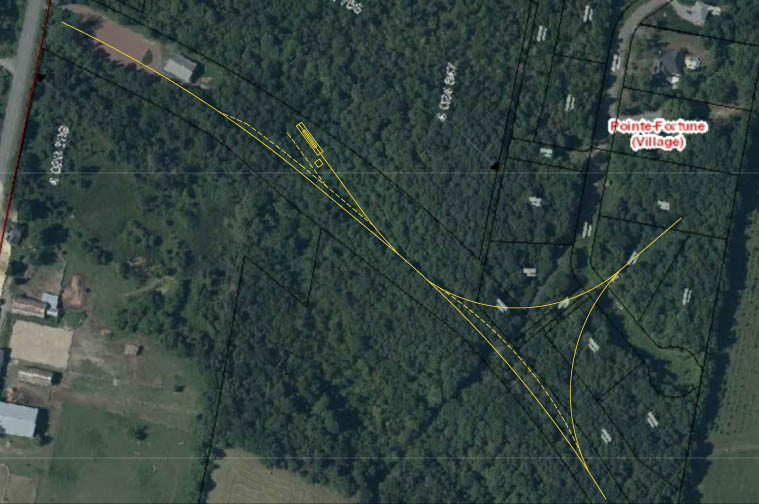
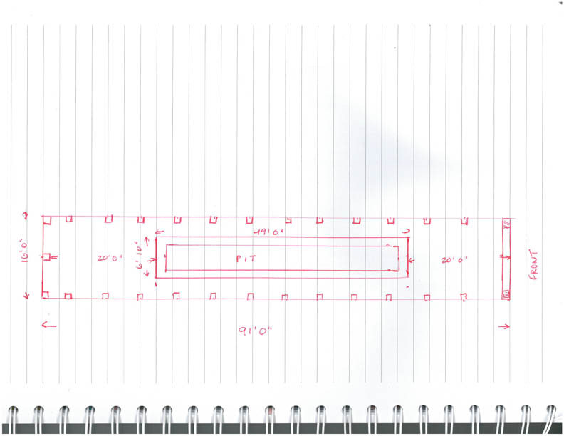
5.19 Canadian Pacific Pointe Fortune
Chris Hall writes (7/2021)
While
out exploring, I found the foundations of a one stall engine house and
a caved in pit in the woods at Pointe Fortune. I can find absolutely
nothing online about it, and was rather surprised to find it. Here is a
photo of the enginehouse pit.
|
