There is a circa 1950 picture
northwards
from Laurier Bridge in Boardroom A at the RMOC Planning Department,
2nd floor, 111 Lisgar Street,
which shows an excellent view of the CNR Freight
and Express Office on Besserer Street and the attached Freight Shed,
which ran south to beyond the future site of the Mackenzie-King bridge,
(under construction in the picture). The shed was built in 1909
and demolished in the 1950's. It had three parallel tracks for
boxcars on the east side, (with through-car loading), and weigh scales
inside the building opposite every loading door. There were also four
team tracks with outdoor raised platforms between them on the east side
of the freight shed.
On the west side of the freight shed
were
the
postal terminal tracks for the Besserer Street building erected in
1937. It was served by two tracks from the station throat and two
from the freight yard ladder track. This building survived for
about ten years after Union Station closed.
An aerial photograph from 1958 shows
the
freight shed gone, but its outline still visible, the coal trestle gone
and replaced by a parking lot at Besserer and Nicholas and by what it
is believed was a pair of bonded warehouses
for the Canada Customs building on Nicholas. The four team tracks
are still there and in use with over a dozen freight cars visible as
far north as the line
of Daly Street. The postal terminal had four cars visible, plus
the two government official cars, stored on the tracks which led from
the passenger throat.
A later aerial photograph from 1965
shows
that although the four postal tracks still had room for 12 cars, only
two were present. The CN express facility at Union Station
appears deserted, but the CP facility has at least 15 trucks at its
loading docks. Perhaps CN Express had already relocated to
Terminal Avenue.
In 1965 the coal track for the steam
plant
at the station has a hopper car
in it. The steam plant functioned untill the end. The very tall
chimney was to be brought
down with explosives so that it would fall across the vacant area
formerly occupied by the yard. Much publicity attended this, and
a large crowd gathered for the event. The charges were set off,
the
stack rocked first one way and then the other, and then just refused to
cooperate. The crowd loved it and applauded the defiance.
It took a couple more days, and some pretty dangerous work, to set more
charges
under the stack, which probably could have colapsed under its weight at
any time.
The CN employee timetables for 1957 and 1965 give some
insights on
the Besserer Street yard tracks. They are referred to as 'A' yard
in the tables of restricted clearances. The tracks are numbered
from west to east. Tracks 1,2, and 3 were east of the freight
shed, with the 1957 timetable showing a restricted clearance on the
west side of track 1 for the shed. The shed was gone in
1965. Tracks
3 and 4 had restricted clearances for a loading platform between
them. Tracks 5 and 6 also had loading
platforms but on both sides.
It would appear that the Postal terminal tracks were not
considered part of A yard, though they came off the same ladder and
were to the west of the freight shed. Likewise, the two tracks
into the bonded Customs warehouse may not have been part of A yard, as
no clearance restrictions are listed, though they certainly existed, as
the buildings were built tight to the tracks.
Besserer St. Yard, was accessed from the through track at
the top
of the passenger yard. In
later years, service was provided by a daily yard job or transfer once
a day, although passenger yard switchers could undoubtedly be called
upon to do an extra switch of the freight sheds if required. The
passenger yard jobs also took care of much of the mail switching since
some of this could figure into passenger trains. In the latter
days as well, there were generally a half dozen
business cars tied up behind the post office. The passenger
switchers also spotted the cars of coal for the steam plant, as this
had to be done when the express operations weren't cluttering up the
lead.
There was also a 'B' yard, possibly the Coach Yard, which
appears
to have been south of the Laurier Bridge. It must have been on
the coach yard ladder, as there was a speed restriction from the end of
B yard into the station.The only restricted clearance was listed in
1957 and 1965 as the Liquor Siding. This was a track behind the
yard office, which had a loading platform on the east side for the
Liquor Commission office and warehouse, (which was on Nicholas Street
south of Laurier Avenue, directly above the yard office and which later
became the Child Guidance Centre of the
University of Ottawa).
The restricted clearances are grouped under four names for
different parts of the Deep Cut to Sappers Bridge layout, (The
timetable still refers to Sappers' Bridge, even though it was torn down
in 1912). "Ottawa Station" applies only to restricted clearances
in the train shed. "Ottawa" applied to restrictions at the
Mackenzie-King and Laurier bridges, "A Yard" and "B Yard"
covered the rest, as described above. CPR main track began at the
switch at the north end of tracks 1 and 2 of the train
shed, however, the track north to Laurier Bridge was still within yard
limits for the station.
CN's two main tracks (designated "double track" in 1957 but
"two
tracks" in 1965) ran from Riverside
(a spring switch) past Deep Cut to the throat of Union Station, where
they converged under or near the Laurier Bridge in a hand-operated
double-slip switch (one of two in the passenger yard) which
fed into the eight tracks of the trainshed. At the
crossover south of the Laurier Bridge, northbound trains approached a
sign indicating "end of two tracks"
while a switch connected
CN's southbound main directly with Track No. 1 almost all movements to
and from that track were made instead through the main throat trackage,
which was protected by a semaphore in one if not both directions. The
signal mast had a doll post on the left to show the signal did not
apply to the canal bank track which continued northwards. The
semaphore signal actually governed movement from either of the two
approach tracks, (which were bidirectional), to the single main leading
through the two double slip switches to the station. The single
semaphore on the north side of Laurier Bridge controlled southbound
movements on this single main to either of the two tracks. All
other movements required hand signals from the switch tenders, who also
controlled the semaphores and mainline switches through rodding from
the switch shanty under Laurier Bridge. South of Laurier As only
Tracks 1 and 2 continued north from the trainshed, one or other had to
be used by CP road engines (and RDC's?) which tied up at Ottawa
West, as well as all CP trains through Hull including transcontinental
and Brockville trains. That gave them the appearance of
being "CP" tracks.
After the Mann Avenue roundhouse closed, there was some
daytime
storage of engines and steam generators
on one of the freight yard tracks; this included the odd cab unit and
also [GMD1s] that ran on the Whitney. Trains and/or
engines were spotted farther out on the station tracks to keep exhaust
fumes out of the train shed and were just left to idle. Near
train time, the switcher would shove them back into the station.
Consistent with CN ownership, all switching of passenger
equipment
was performed by CN engines and crews. This included turning of
train consists by means of the wyes at Hurdman. The 1957 CN
Employee timetable includes instructions that the eastbound
Supercontinental, and both east and westbound Continental take the wye
to Main St. before backing into Union Station. The westbound
Supercontinental went straight in to Union Station (to minimize the
Montreal-Ottawa trip time) and wyed on its way out of town. As
the western Queensway extended easterly across the Rideau Canal and
Main St around 1965 the CN transcontinentals could no longer turn at
"Deep Cut" and had to back up quite a long distance to turn at Hurdman.
The CAR yards were situated along the
west
side of the Rideau Canal. The yards
extended to Neville Street, (todayWaverley), at the right-angle bend of
the canal. The yard north of Archibald (Argyle) Street was
entirely a lumber storage facility, with tracks running between
all the log piles. The piles were 10 feet to 30 feet high,
according to the maps. The yard was about 1800
feet long, measured along the canal, and a maximum of 800 feet deep
measured back from the canal wharf.
Although labelled "Canada Atlantic
Yard",
the
lumber yard was also labelled "Bronson
and Weston". Bronson was a lumber merchant and landowner.
The yard was almost entirely south of the then city limits of Ottawa at
Ann Street (Gladstone), except adjacent to the canal, where it
projected northwards in a small pocket on the
east side of Robert Street, which was the alignment of the eastern
boundary of the earliest land grants, (in line also with Main
and Waller Streets).
East of Cartier, the plan showed an unusual yard with six
tracks
extending north to Ann Street (now
Gladstone Avenue). All the tracks in this yard, which lay
entirely within William Stewart's land, were fed by a turntable, rather
than turnouts. Today there are houses on part of this land. The
canal wharf was on the west side of the canal running up to a point
opposite Gladstone, again within Stewart's land. There was
trackage on the wharf and a
couple of tracks continuing further northwards, as
far as a street named "Neville", about at the distance of today's
Somerset Street.
A 1957 CNR Employee Timetable refers to an ice house track
in its
restricted clearances list. The
timetable also refers to a cinder pit at the Elgin St. Yards.
Prior to the removal of the CN tracks to Elgin Street about
1965,
it was a busy place with trains
turning and local businesses still being serviced. The Driveway did not
cross the tracks on the west side of the canal but entered as does the southbound lane now by going to Elgin Street next
to the Tiffany Apartments. Colonel By Drive originally started
south of Hawthorne Avenue at the Pretoria Bridge. That part of
Colonel By Drive that now goes under the Queensway was then Echo
Drive. There was a watchman at the Echo Drive crossing (as well
as the Main Street crossing) and he was a busy person in earlier times
with
all the shunting that went on. The watchman's shanty had a round,
white and black crossing sign hanging outside that he would hold up to
the cars.
The buildings east from Bank Street on
the
south side along Isabella were:
- Yard Office, Ice House, Coal Shed, Coal
Ramp,
Platform, Stock Pens.
On the north side east of Bank Street
along
Catherine were:
- Brewers Warehousing, Car Shops three
Stores
plus a similar sized unlabelled building at the east end running
north-south.
The Bridges and Buildings Book of 1908
has
the following dimensions for these
buildings, which can be compared against the
sizes estimated from the NCC plan from 1963 (shown in parentheses).
Stores 24.5 x 72 (cf 70 x 24 for Yard
Office. The bridges and buildings book shows a 12 x 12 Yard
Office, which may have been relocated to the stores building.)
Ice House 104 x 32 (cf 140 x 35)
Coal Shed 698 x 39 (cf 665 x 35)
Coal Ramp 240 (165)
Car Repair shop 440 x 45.5, Car Repair
shop 250
x 80.5, attached boiler room 19 x 42 (combined 680 x 35 with
protrusions).
The east Car Repair shop is 465x45,
the west
shop is 245 x 80, and the boiler house extension to the south at the
west end is 42 x 20. The ice house
length
may be a typographical error in the book.
A June 1910 picture (PA-42484) taken
from
the
cupola of a snowplow on the main
line at the Bank Steet Yard Office looking east. It shows the
Isababella Street Coal Shed with a decided tilt. It seems that it
either fell down or was demolished a little
after that and there was an
agreement
between the Coal Trestle Company and the GTR dated 25 October 1916
concerning the new coal trestle. There was, subsequently,
an application by O'Reilly & Belanger Ltd. for an order directing
the GTR to provide reasonable and proper
facilities for the unloading, handling, storing and delivery of the
applicant's coal at the coal trestle erected upon the lands of the GTR
in its station yards at Isabella Street, Ottawa and for a mandatory
order directing the railway to terminate the agreement or lease made
between the railway and the Coal Trestle Company Ltd. dated 25 October,
1916. The BRC decided that it has no power to fix the rental rates for
space owned by the Coal Trestle Company at Isabella Street, Ottawa and
denied the aplication. It seems that not all the coal companies
were prepared to pay to lease space in the new, more expensive facility.
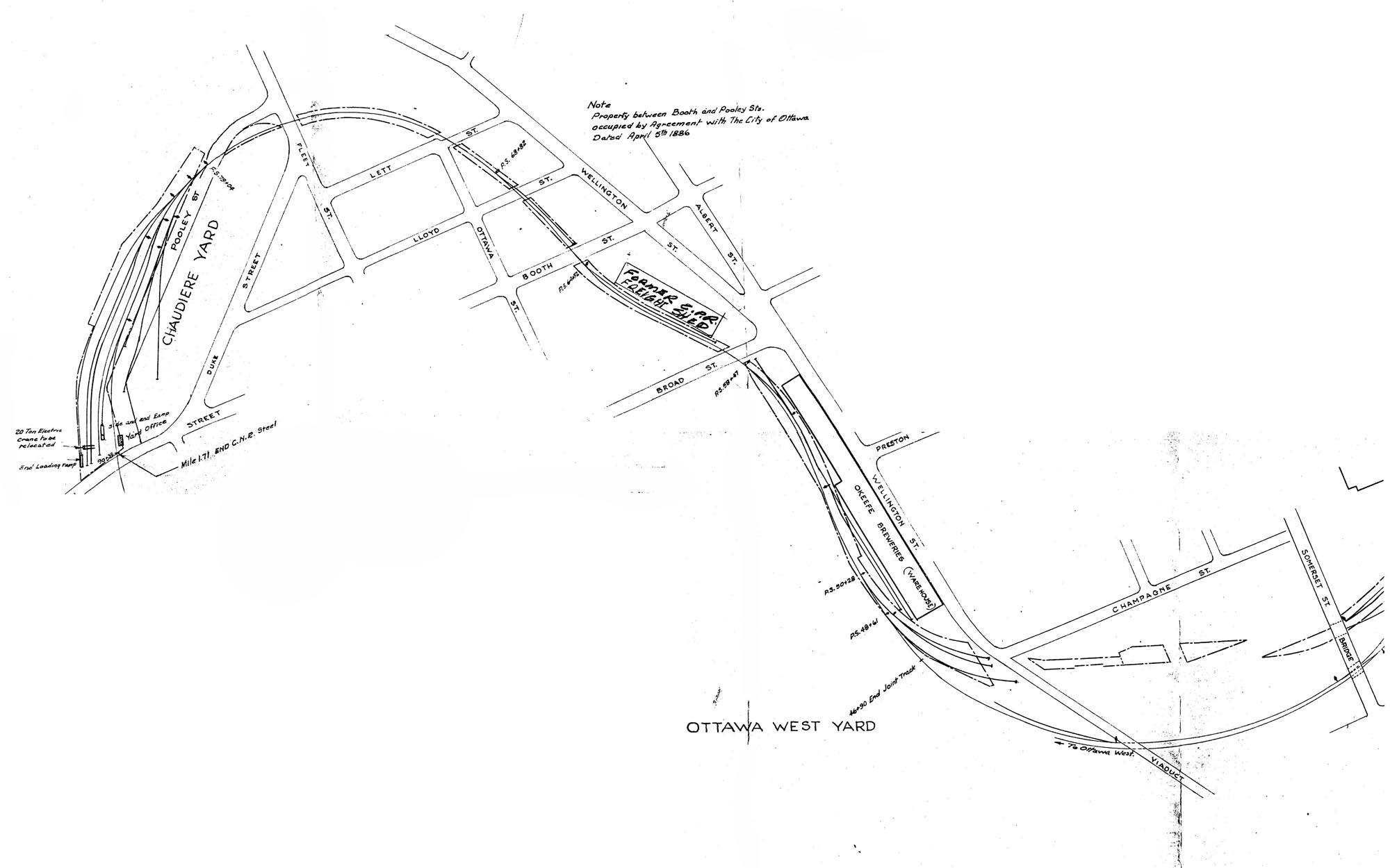
3.4 CNR Ottawa West Yard