Salient Features of the O
TRAIN (Trillium) Route
Between
Bayview and Greenboro as of August 2017

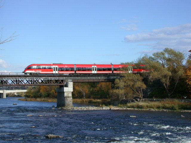
A northbound train on the bridge over the Rideau River
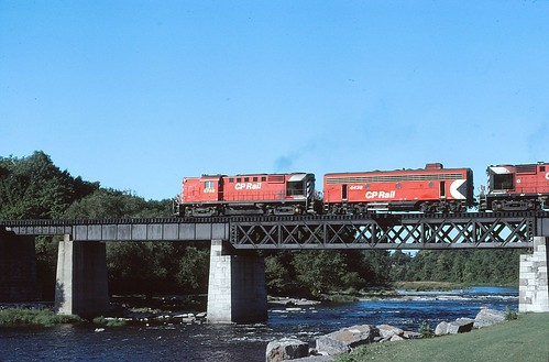
This is an interesting earlier picture taken by Ray McDermott of an unusual combination
of MLW RS-18 road switchers bookending a GMD (Canada) F7 B unit crossing the Rideau in 1981. Freight trains no longer use this route.
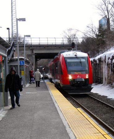
A southbound Lint train departing Carling on 18 March 2015. Picture by Bert Titcomb.
A northbound train on the bridge over the Rideau River
This is an interesting earlier picture taken by Ray McDermott of an unusual combination
of MLW RS-18 road switchers bookending a GMD (Canada) F7 B unit crossing the Rideau in 1981. Freight trains no longer use this route.
A southbound Lint train departing Carling on 18 March 2015. Picture by Bert Titcomb.
|
The main features of this line
are shown in
the table below. The
O Train runs from
Bayview station (north) to Greenboro station (south). Passengers travelling southwards
should read the
table from top to bottom while those travelling northwards should read
from bottom to top.
History of the line The line between Greenboro and
Chaudiere Junction was built by the Bytown and Prescott Railway as part of their line
between Prescott on the St. Lawrence River to Ottawa, Sussex Street. This section was built in
November 1854 and
opened to traffic
in December 1854.
The section of line from
Chaudiere Junction to the switch leading to Bayview Station was built by the St.
Lawrence and Ottawa Railway, the successor to the Bytown and Prescott,
and opened to traffic on December 13, 1871.
The
line was acquired by
the Canadian Pacific Railway in 1884 and was subsequently sold to the
city of Ottawa
in 2005. The
short length of
line from the
switch to Bayview Station was built for the opening of the
O Train on October 15, 2001. When originally built, the line crossed
the
Rideau Canal at Dows Lake on a swing bridge and then skirted Dows Lake. It then ran at ground
level with many
crossings at grade with city streets.
In
order to eliminate these crossings, the Federal Government funded the
tunnel under Dows Lake as well as the cuts leading to it. The lowering of
the tracks and associated grade separations was completed in 1966. Kilometer posts are located on
the west
side of the line while signals are mainly to the right of the train in
the
direction of travel (i.e. on the east side for northbound trains and on
the west side for southbound trains. The line was relaid with
continuously welded rails in July 2004 with the exception of the bridge
over the Rideau river which is jointed rail.
The original Talent diesel multiple units ceased operating on 27 February 2015 and the Coradia Lint diesel multiple units commenced operations on 2 March 2015 |
| Km | OC
Transpo Transitway
overpass. Opened in 1981. |
| Bayview
station. Built
for the opening of the O Train on October 15, 2001. The platform
track will be extended a little way northwards to a new platform under
the Confederation line platform due to open in May 2018.From 1966
to
the late 70s CPR operated a shelter called Ottawa West on the main line
to the northwest of this point. Ottawa West was used by Budd
Rail
Diesel Cars (RDC's) running between Ottawa Station and Montreal via
Hull/Gatineau and Lachute. |
|
| Albert Street overpass, originally Wellington and Scott Streets. Built in its present location in 1968. The CPR Ottawa West roundhouse stood in this area until April 1968. | |
| The track between Bayview station and the switch towards the Prince of Wales Bridge is defined as a spur and CROR Rule 105 applies. | |
| Switch
to Bayview
Station. Start/End CTC. Put in for the opening of the O Train on
October
15, 2001. The
line to the Prince of Wales Bridge is
protected by a derail north of the switch at the end of the signalled
area.
No trains have travelled
across the bridge since 26 July 2001. The frog to this switch
was
removed in the summer of 2010 thus severing the link to the POW bridge. The switch was later changed to plain track. |
|
| 7.4 | Two aspect signal 74. Applies to southbound trains entering Gladstone passing track.. |
| Somerset
Street overpass.
The original bridge here was built in 1896 and widened
by the addition of a second bridge on the south side in 1907.
It
was
reconstructed in 1928, 1966 and 1982. |
|
| 7.3 | Two aspect signals 73W and 73E. Controls entrance to single track to Bayview. (northbound trains) |
| Gladstone passing track brought into service in March 2015. On the west side is former railway
switch back, to serve Bruce Fuels and Standard Bread . This was
removed
in 1987. On the east side can be seen the curved City Centre complex, formerly rail-served, which was opened in 1962-3 | |
| Two aspect signal 7. Controls entrance to east Gladstone passing track - northbound trains. | |
| 7 | Kilometer post 7. |
| Two aspect signals 70W and 70E. Apply to southbound trains entering the single track towards Carling | |
| 6.9 | Two aspect signal 69. Controls entrance to west Gladstone passing track - northbound trains |
| Gladstone Avenue overpass. Opened in 1966. | |
| Queensway overpass. Opened in 1965. | |
| Young Street pedestrian overpass. Opened in 1966. | |
| Beech Street overpass. Opened in 1964. The brick-built former warehouse to the north-east used to have rail access. | |
| Hickory Street pedestrian overpass opened in August 2016 | |
| 6.1 | Two aspect signal 61. Applies to Northbound trains. |
| Carling station. Built for the opening of the O Train on October 15, 2001. | |
| Two aspect signal 60. Applies to southbound trains. | |
| Carling Avenue overpass. Opened in 1964. | |
| 6 | Kilometer post 6 |
| Prince of Wales Drive overpass. Opened in 1964. | |
| 5.6 | White
signal 56. Applies
to southbound trains. When lit this indicates that the
tunnel is not flooded with water. |
| Tunnel under Dows Lake. Opened in 1964. Click here for a 1963 diagram | |
| 4.9 | White
signal 49. Applies
to northbound trains. When lit this indicates that the tunnel
is
not flooded with water. |
| Carleton University Overhead Parking Garage. Opened 2014 | |
| Campus Avenue overpass. Opened in 1969. (Originally known as Sunnyside Road). | |
| 4.4 | Two aspect signal 44 controls entrance to Carleton station |
| 4.3 | Two aspect Signals 43W and 43E. Applies to northbound trains. Controls entrance to single track section to Gladstone. |
| Carleton
station passing track. Built
for the opening of the O Train on October
15, 2001. Passing track originally with
spring
switches at each end. The spring switches were replaced by motorized switxhes in the spring of 2017. |
|
| 4.2 | Two aspect Signals 42W and 42E. Applies to southbound trains. Controls entrance to single track section to the Ellwood Diamond. |
| Pedestrian
underpass.
Built for the
opening of the O Train on
October
15, 2001, replacing
an earlier culvert underpass. |
|
| 4 | Kilometer post 4. |
| Pedestrian
underpass.
This was originally built about 1912 to allow
narrow gauge
trains to pass under the railway. They were used to transport
earth and clay from the vicinity of Hartwell's Locks to fill in a
swampy area, including an inlet of the Rideau River, at the south end
of Bronson Avenue, now known as Brewer Park. It was rebuilt
in
1926 as a concrete slab underpass. For further details of the narrow gauge railway see ../circle/findings3.htm#CUtramway |
|
| University Road underpass. Reconstructed into the present form in 1967. | |
| Rideau
River bridge.
The first bridge at this location (1871) was a wooden one
with
three 100 foot spans. It was rebuilt in 1882 and the new
bridge
was painted white and known locally as the "White Bridge". It
was
replaced in 1912-13 by
one 100 foot deck lattice span, two 60 foot plate girder spans and two
30 foot deck plate girder spans. One of the spans was brought
in
from
Magog, Quebec. The north end was rebuilt in 1967. A cycle
path
runs under
the south end of the bridge. Except for the rails over this bridge the
line is laid with continuously welded rails laid new in July
2004. An emergency walk way was installed in 2001. The bridge
and
piers was renovated in the summer of 2010. For further details of the bridge's history see see ../circle/Findings_Bridges.htm#St.LORideauRiver |
|
| Vincent Massey park. West side. | |
| Riverside Drive overpass. Reconstructed in its present form in 1962, previously a wooden bridge. | |
| Tunnel under Heron Road. Constructed in 1970. | |
| Confederation station. Built for the opening of the O Train on October 15, 2001. | |
| 2.8 | Two Aspect Signal 28. Applies to southbound trains. |
| Airport Parkway overpass. Opened in 1973. | |
| On the east side can
be seen the location
of the former
connecting line to the line now used by the VIA Rail Canada trains.
The connecting switch was removed in June 2003. At
one time
there was also a connecting track in the south west quadrant
but
although there were plans to do so, there was never a connection in the
north east quadrant. |
|
| Ellwood
Diamond. This
diamond or flat crossing was constructed in 1910 when the Canadian
Northern Ontario Railway built its line across the Canadian Pacific
Railway line. The original manually operated interlocking
plant
was
replaced by an automatic protection system in 1936. This line is now
used by VIA Rail Canada trains to and from Toronto. This is
erroneously
labelled "Ellwood Junction", it should be "Ellwood Crossing" or
"Ellwood
Diamond". |
|
| OC Transpo Transitway overpass, opened in 1996. | |
| 2.3 | Two Aspect Signal 23. Applies to northbound trains. |
| Bridge over Sawmill Creek. This bridge was reconstructed in 1914 and in the summer of 2001 in preparation for the opening of the O Train. | |
| 2.18 | Brookfield
Pedestrian
Way. Crossing at kilometer 2.18. This was closed in 2014 and a pedestrian underpass was constructed in 2015 |
| 2 | Kilometer post 2. |
| Two aspect signal 20. Applies to southbound trains. | |
| 1.9 | Two aspect signals 19E and 19W applies to northbound trains. Controls entrance to single track section to Carleton. |
| Brookfield double track section, brought into service in March 2015. | |
| 1.6 | Two aspect signals 16W and 16E. Controls entrance single track southbound trains towards Greenboro |
| 1.3 | Three aspect signal 13 applies to northbound trains. Controls entrance to Brookfield double track section. |
| Walkley Road overpass. Opened in 1978. | |
| 1 | Kilometer post 1. |
| Chaudiere
Junction curve.
Here the line curves away from the original line
which ran
northward to Sussex Street. Originally this was known as Chaudiere
Junction and later became known as Ellwood when the railway named
Ellwood Station after two local families, the Ellises and the Woods. |
|
| 0.7 | Two aspect Signal 7. Applies to northbound trains. |
| 0.6 | Two aspect Signal 6. Applies to southbound trains |
| Disused siding to LCBO warehouse. | |
| North connection to Walkley Yard. Opened in 1961. | |
| 0.5 | Single aspect
Dwarf signal 5 controls
northbound movements from the Walkley Yard connection on to the main
line. |
| Walkley
Diamond. This
is a diamond, or flat crossing, with the Walkley freight line which
connects the Walkley freight yards, to the east, with the main line, to
the west. This line was built by the National Capital
Commission
and opened to traffic on November 19, 1953 as part of the scheme to
route trains away from downtown Ottawa. The O Trains are
maintained in Walkley Yard. |
|
| OC Transpo Transitway underpass. Built about 1992. | |
| South connection to Walkley Yard. Opened in 1967. | |
| Three Aspect Signal 1. Applies to northbound trains. | |
| Greenboro station kilometer 0. Built for the opening of the Southeast Transitway in 1994 and expanded to include the platform and footbridge of the O Train on October 15, 2001. The design of the addition was conceived by the late Darrell Richards, former Transport 2000 president, who is commemorated by a bronze City of Ottawa plaque in the station. The line continues southwards. A few CN train a year deliver equipment to be tested to the NRC facility near Lester Road. Unused rail continues to just north of Leitrim Road. and will ecventually become part of the planned extension southwards and to the Ottawa Aiirport. |
![]()
Updated 9 August 2017.