|
OTTAWA
RAIL ARTEFACT DISCOVERY SPRING 2016 A
single-shoulder, 3-hole tie plate with a spike through it, was found buried in the
sandy soil of the north raised embankment of the 1913 CNR rail spur into
Uplands. The location was ~100 metres SE of the Airport Parway (at the point
where the west off-ramp to Uplands Dr/ Alert Rd begins). Inspection of the NRC
topographical map from 1914 indicates the rail spur curved southward around
this point, to the ballast pits, presently between Alert Rd and the NRC Rail
Test Facility.The spur embankments at this location are evident on aerial maps
from 1965 to present (GeoOttawa website), however all traces of the rail bed
between the Airport Parkway and Uplands Dr were obliterated with the 2011 construction
of the EY Center. SINGLE-SHOULDER,
3-HOLE TIE PLATE DIMENSIONS 10
½” x
7” WEIGHT ~10 ½ lbs ONE ¾”
SQUARE HOLE 2 5/8” FROM TOP AND 3 ½” FROM SIDES TWO ¾”
SQUARE HOLES 8 5/8” FROM TOP AND 2” FROM SIDES
RAIL-SIDE ¼” HIGH
SHOULDER 3” FROM TOP
(MAX PLATE THICKNESS 5/8” HERE) RAIL-SIDE
SHALLOW HORIZONTAL RIDGE 8 ½” FROM TOP
(PLATE 7/16’’ THICK HERE) RAIL-SIDE
FROM SHOULDER TO TOP, IS BEVELLED IN A SHALLOW WEDGE TIE-SIDE
4 HORIZONTAL RIDGES ‘CLEATS’ 2 7/8”, 5 1/8 ”, 7 ½”, 9
¾” FROM TOP TIE-SIDE
RIDGES ‘CLEATS’ ~ 1/8” HIGH RAIL-SIDE ALPHA-NUMERICS CAST ABOVE THE SHOULDER:
2 - 12 - 19 IE PAT
- 6 - 3 - 13 LUИ VII - 1921 A SPIKE LENGTH 6” SHAFT
5/8” SQUARE 1” TAPER TO POINT OVAL
HEAD 1 ¾” x 1
½” (5/8” MAX THICKNESS) COMMENTS 2 -
12 -19
? PAT -
6 - 3 - 13 patented June 3, 1913 VII - 1921
manufactured July 1921 ? RAIL
BASE WIDTH
5 ½” Dudley 105 pound per yard jointed
rail CONCLUSIONS Colin
informed me that the present 1913 patended tie plate was used between the rail
and the wooden tie to spread the load and reduce wear on the tie, and the
design is a garden variety railway item . It was unearthed with a spike
embedded through the shoulder hole. Whether the spur played a role in the
construction of the 18-hole golf course, established north of Hunt Club Rd in
1920 is unknown When the spur was ripped
up, evidentally the rails were removed without full withdrawal of the spikes.
Likely a broken tie with attached plate and spike, was discarded on the
embankment. The well drained sandy soil at this location would have inhibited
corrosion of the steel artefacts. What width of rail base did the Canadian
Northern Ontario Railway use for the 1913 Beachburg Sub? Inspection
of the 1965 GeoOttawa aerial map reveals the rail bed at this location, was
part of a ‘service road’ which terminated at the CPR siding, presently part of
the NRC Rail Test Facility. In 1965 there was a lot of construction at the
airport and C.F.B. Uplands. Colin
thank you for your excellent railway info (http://churcher.crcml.org/circle/findings2.htm#Uplands) which is an essential
tool for the historian/ archaelogist. The rail beds are often the only man-made
constant throughout the years. 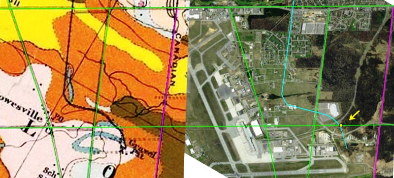 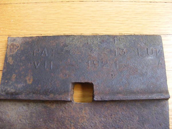 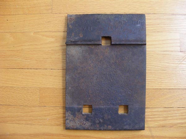 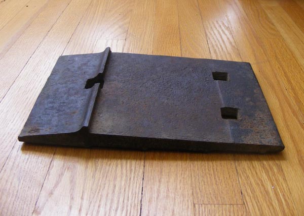 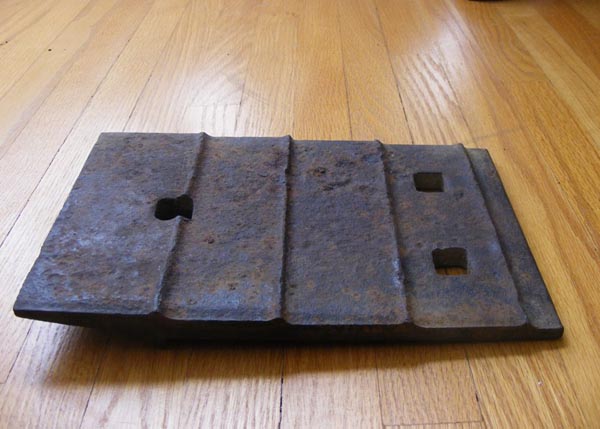 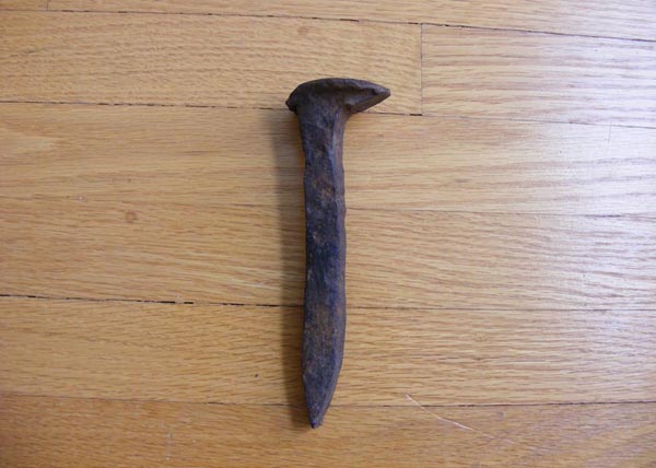 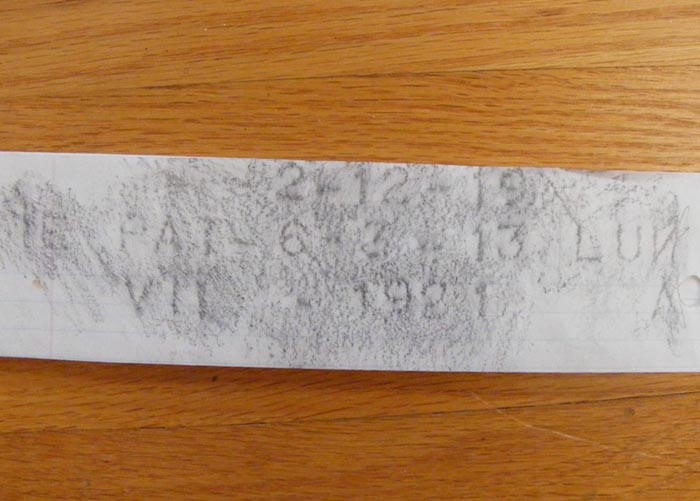 |