Walter Shanly's Report
| The Bytown and Prescott Railway was formed in
1850 and one of the first steps was to survey a route. This was done
by Walter Shanly, the distinguished civil engineer who would eventually
become a Member of Parliament and exercise considerable influence
in nineteenth century railway matters. In these days of GPS satellite
systems it is difficult to imagine how surveys were carried out 150 years
ago. Because of the dense swamp, the only practicable time of year
to survey was when the snow was on the ground. With but two assistants,
Shanly surveyed the route on snowshoes during March 1851. At night,
he slept out in the open or sheltered in the small hamlets along the route.
He surveyed three routes which means that, in effect, he walked on snowshoes
between Bytown and Prescott three times. This is the text of his published
report. |
REPORTS
BYTOWN AND PRESCOTT RAILWAY OFFICE,
To the President and Directors of the Bytown and
Prescott Railway Company - PRESCOTT, 7th APRIL, 1851. GENTLEMEN— Acting upon instructions conveyed to me by your
Secretary, in the form of a Resolution passed at the first meeting
of your Board,
1st The Western Route—via Kemptville
and on West of the Rideau.on the 17th February last, I shortly afterwards proceeded to explore the Country from Bytown to Prescott, for the purpose as well of ascertaining the general facilities for the construction of a Railway between those places as for instituting a comparison between the several routes defined in the Resolution referred to; and have now the honor to lay before you the following Report on the result of my examinations. Your instructions to me bring under my notice four several Routes, which bind me, in all but one instance, to a certain intermediate locality. These Routes I have classified as follows :— 2nd. The Middle or Direct Route. 3rd. The Eastern or “Heck's Corner” Route. 4th. The Kemptville Route—keeping East of the Rideau. Before entering on a description of these several lines, I would beg leave to observe that I made no attempt to effect more than a cursory and general examination of the Country : my explorations 4
having been carried on at a period of the year
when it is not practicable to obtain the data requisite, for arriving
at a reliable estimate of the cost of such a work as you are embarked
in. The Surveys essential to such an estimate could neither
be conducted within properlv economical bounds at that inclement
season of the year - nor, if made, would the results be satisfactory-The
deep covering of snow rendering it impossible to obtain a sufficiently
correct knowledge of the nature of the ground to be worked upon.
Having traversed the country from the Ottawa to the St. Lawrence, on foot, as nearly upon the ultimate location of each of the proposed Routes as mere ocular examination would admit of, I feel very confident that the conclusions I have arrived at will be borne out by the result of future and more accurate examinations; and the knowledge obtained of the country enables me so nearly to point out the proper "whereabouts" of the projected Railway as to preclude the necessity of actually surveying all the Lines under consideration—-thereby effecting not only a considerable saving of time, but also admitting of the “locating” expenses being kept within the narrowest limits compatible with obtaining the most advantageous Line. I shall now proceed to take up, in the order above given, each of the proposed Routes - briefly describing the general features of the country through which they pass, and their location with regard to each Township intersected. The Western Route.
To those acquainted with Bytown, and its position with regard to the Rideau Canal, it will be obvious that the proposed line on the west side of the Rideau River should be located with a view to having its Northern terminus on the west side of the Canal; as well to avoid the inconvenience inseparable from crossing navigable water as to shun the abrupt descent which would then become necessary in order to reach the lower lands on the East. Two points present themselves for this terminus - the one at or near the Canal Basin— the other near the upper end of the Town, fronting directly on the Ottawa River, at the foot of the precipitous cliffs on the rear of Wellington Street. Departing from both of these points I find feas- 5
ible routes, which fall in with one another nearly
opposite to, and about half a mile west of Hartwell's Locks. Thence
my course was nearly parallel with the Rideau River as far as Lot
No. 17 in the 3rd Concession Nepean,-—from which point I took an
undeviating straight course to Prescott.
of the rival Routes may be definitely selected,
the point of departure from Prescott will remain the same.Leaving Nepean about the middle of the 3rd Concession I passed diagonally through North Gower, l½ mile to the East of the little village of "Stephensville," crossed the extreme South Eastern angle of Marboro', intersected the Rideau River and Canal, about half a mile below " Beckett's landing," and crossed the South Branch of the Rideau at Kemptville, 2½ miles further West—thence through the Township of Oxford, cutting the line between it and Edwardsburgh at or near Lot 21 of the former—my route through Edwardsburgh crosses the ‘Nation’ River about ¾ of a mile West of Spencer's Mills—at a point very favorable for Bridging the Stream—and reaches the St. Lawrence in the Town of Prescott. The country throughout may be termed very favorable for the cheap-and speedy construction of the Railway. The main difficulties are to be encountered in the Townships of Nepean and Edwardsburgh, where the approaches to the Termini will involve considerable expense. About three fourths of the route is through wooded land, for the most part Cedar and Tamarac Swamps— which, however, have generally firm substrata of sand or gravel at an inconsiderable depth below the upper, vegetable coating—and are susceptible of drainage. The Bridging on this Route will form a considerable item in the expense of construction. The undernamed Streams are to be crossed:- The Jock,................……………………in ...... Nepean. Stephen's Creek, .....………………….. ”.......North Cower The Rideau. The South Branch of the Rideau, “...….Oxford. The Nation River, .....…………….........” ......Edwardsburgh. The South Branch of the Nation, ……....”..... " all of unimportant magnitude with the exception of the Rideau and the Nation—and the bridging of the latter being common to all the 6
routes under consideration need not be more particularly referred to here. The Rideau at its intersection with my Line is about 400 feet wide, with a depth of water in the centre of upwards of 20 feet. The crossing of this river is invested with more than ordinary difficulty from the fact of its being not merely "navigable water" but from its having been rendered so by artificial means—and at an immense outlay—by the Imperial Government whose property it is. This circumstance would render necessary the construction and maintenance of a Draw Bridge. A wide margin of drowned lands to either side of the River would further add to the expense of carrying the Line across it. A more favorable site for a bridge is to be found a short distance above Beckett's Landing; but would occasion considerable curvature, and consequently increase the length of my Line. No more direct route from Bytown to Prescott can be obtained West of the Rideau than the one above laid down. The Middle or Direct Route.
An absolutely direct route from Bytown to Prescott
is not practicable, without crossing the Rideau Canal three times.
The one I have selected, however, as most direct, in view of not
interfering with the Canal, differs, for all practical purposes,
but little from a Straight Line. Leaving Lower Bytown at some convenient
point, hereafter to be determined on, it crosses the Rideau near
the foot of the lofty sand ridge, and curving swiftly to the South,
runs through the Gore of Gloucester in a nearly Southerly direction,
reaching the summit of the table lands, by a gradual ascent, somewhere
about Lot No. 17, in the rear of Mr. Billing's residence, and enters
the Rideau Front of Gloucester near the angle of the 2nd and 3rd
Concessions,—passing about half a mile to the rear of Cunningham's Tavern,
it strikes the Osgoode Line at the Eastern angle of its 2nd Concession,
and running diagonally through this and the 1st Concession, enters South
Gower at the North Easterly angle of the Township, and crossing it diagonally
cuts the Edwardsburgh Line7
a little East of the Oxford and South Gower corner—thence through Edwardsburg crossing the Nation River ¾ mile to the East of Spencer's Mills—and reaching the St. Lawrence at the same point as the Western Route. The most expensive portion of this Route will be found in the Township of Gloucester. The Line through Osgoode and South Gower is very favorable. In Edwardsburgh there will be no more than average work to be done except on the approach to the St. Lawrence. The proportion of wood lands on this route is about the same as on the Western—three fourths of the entire distance,—and the character of the country generally similar—presenting upon the whole a desirable Railway Line. The Bridging will be confined to the following Streams - The Rideau - The Nation - The South Branch of the Nation. The point of crossing the Rideau, close to Bytown, where the Stream is not subservient to the purposes of navigation, offers, in every respect, a most eligible site for bridging at a moderate cost. The other two Streams are of minor importance. This Line leaves Kemptville about 3¾ miles to the West, and Heck's Corners half a mile to the East. The Eastern or Heck's Corners Route
Takes its departure from Bytown, and crosses the Rideau, at the same points as the route last described—passing across the Gore and an angle of the Ottawa Front of Gloucester, it enters the Rideau Front on the rear of the 6th Concession, continues in this Concession throughout the Township, and enters Osgoode on the rear of the 5th Concession, and following the lowlands in front of Rossiter's Tavern and J.C. Bowers' Store, running nearly parallel with, and within a short distance of the Stage road to Prescott, cuts the Mountain line in front of the 2nd Concession of Osgoode, crosses an 8
angle of Mountain, enters South Gower on the 5th Concession, and passing close on the West of Heck's Corners, becomes identified with the middle route at the Edwardsburgh Line. The features of this Line throughout the Township of Gloucester do not materially differ from those of the corresponding portion of the direct route. Through Osgoode, Mountain, and South Gower, the land is of a more varying character, presenting an undulating surface and some stony ridges. The proportion of 'improved' land is greater on this than on either of the foregoing routes. The Bridging will be the same on this as on the middle Route—with one addition. The Line crosses the ’Castor’ in Osgoode,— but at a point where the Stream is of inconsiderable width. Kemptville lies about 5 miles West of this Route. The Kemptville Route, (East of the Rideau.)
The most feasible plan of constructing the proposed
Railway so as to touch Kemptville without interfering with the Rideau
Canal, would be to adopt the middle Route as far as .Lot No. 32,
in the 2nd Concession of Osgoode—thence, taking a direct line to
Kemptville, to fall in with the Western Route on the South of, without
crossing, the South Branch of the Rideau. From which point the Western
Route should be followed to Prescott. This link, connecting the middle
with the Western Route, would be about seven miles in length, passing
through low level land, where drainage will constitute the largest
proportion of the cost of grading the Roadway.The amount of Bridging will be the same on this as on the middle Route. Comparison of the Routes.
In point of length, the several Routes will compare very nearly as follow, the distance being taken from the maps of the Townships:- 9
The Western Route ........ about ...…... 50 miles. The Middle “………..” …...…. 50 “ The Eastern “…………” ………... 52 “' The Kemptville”…………” …........... 52 “ (The starting point of the Western Route is nearly a mile South of that of the others.) The Eastern, it will be observed, is the longest of the Routes, whilst its facilities of construction are inferior rather than otherwise to those possessed by the shorter ones. It is evident, therefore, that it would be inexpedient to adopt it as the Line of your Railway. I shall at once proceed, then, to weigh the relative advantages and disadvantages of the Western and Middle Routes. As respects the grading of these Lines, the natural advantages are very nicely balanced — though upon the whole I incline to believe that an instrumental examination would be in favor of the Western. It is upon the Bridging and the advantages presented for forming the northern terminus, will hinge the decision upon the relative merits of these Routes. The number of feet of Bridging on the Western is about double that on the Middle Line, and the average cost per Foot will be greater on the former on account of the extraordinary expense attendant on crossing the Canal. The estimate of this portion of the work on the Western Line will be in excess of that on the Middle Line in the proportion of nearly 2 to 1. The Draw Bridge to accommodate the navigation of the Rideau, creating a break in your road, would be a source of much inconvenience— which it would be desirable to avoid at even an increase of cost. The Bridging, therefore, both in point of cost and convenience, is in favor of the Middle Route. The selection of the Southern terminus is a matter requiring more careful. examination than I have yet been able to give it — nor is it necessary that it should now be decided on, because whichever 10
The Northern terminus must be peculiarly, circumstanced
with regard to the Ottawa. The lofty and precipitous nature of
the banks, together with the extraordinary fluctuations of the River,
(reaching 20 feet, I believe,) render it impracticable to run the
Track down so as to suit the loading and discharging of the water-craft.
All freights arriving by the Lower Ottawa, must, therefore, be raised,
to the level of the Town by some artificial contrivance. Supposing the
terminus .at. the Canal Basin to be selected—this lifting, could be.effected
by means of the Locks,—but the plan is objectionable. Firstly,—because,
the lift at that point would be very much greater (upwards of 80 feet,)
than at either of the other points, and that method of raising burdens
a tedious one—even were the Locks exclusively in .your possession. Secondly,—because
by locating the terminus at the Basin you would render yourselves
dependent for your connection with the Ottawa upon a work not under
your own control, and with interests to a certain extent adverse
to yours. This would be certain to prove a fruitful source of annoyance
and inconvenience—sufficient in itself to warrant a decision against this
location as the terminus of your Railway.
The other point proposed, at the upper end of the Town, possesses the advantage of admitting of the Track being carried down nearly to high water level,—which would modify; without obviating the evil of having to lift freights from the River, but the construction of a Depot at this place would be attended with very great expense, from the fact that every foot of ground would have, to be "made," by building piers in very deep water, and cutting away the lofty cliffs to the rear; and even in this way it would be hardly possible to obtain the space that, it is but fair to expect, the business of the Bytown and Prescott Railway will ere long require. In those two particulars, cost and space, the location in question compares very disadvantageously with that which I would select as the terminus of the direct Route, that is on Lot Letter "O" in Lower Bytown, where the ground presents a uniform surface, capable of being converted into a convenient Depot ground at comparatively small expense. 11
This, combined with the advantages already detailed,
renders it incumbent on me to pronounce it for the interest of
your Company to adopt the direct in preference to the Western Route.
It now only remains to be considered whether there are such advantages to be secured by touching at Kemptville—thereby adding about two miles to the length of your Road, as would render it expedient to adopt that Route. I am not yet in possession of data sufficient to warrant me in giving a decided opinion upon this point; but the course I would recommend is this,—That a thorough survey be made of the direct Route—that the Western Route be also surveyed from Prescott to Kemptville, and thence the link connecting the two Routes—should the estimates resulting from these surveys show that the extra cost to be incurred would simply be in the construction of the increased distance at the average cost per mile of the other portions of the Road, I think it would be well worthy of consideration, whether it would not be to the advantage of your project to adopt the Kemptville Route. A Station on the Rideau Canal, at a point so central to the Line as Kemptville, would doubtless present some advantages,—-giving you a water communication with several rich and productive Townships to the West, and rendering the Canal in a measure tributary, instead of rival, to your interests. Costs
The examinations thus far made, being, as already
stated, of a general character do not furnish me the means of forming
more than an approximate estimate of the cost of the undertaking.
From present appearances I consider that the grading, ballasting
and superstructure of the Road can be completed for a sum not exceeding
£3700 per mile—assuming this estimate as correct we have for
the total cost of
The Direct Route,.............................
£185,000" Kemptville Route,….................... 192,000- The Western Route would exceed the direct one in cost by the 12
difference in expense of Bridging and forming the Depot-ground at Bytown,—which difference I would not venture to put down at less than £15,000,—making the total cost of that Route, £200,000. The above estimate is predicated upon the contracts for iron being effected whilst that article is at its present low figure in the English Market. Summary of the Characteristics of the Road.
Apart from the question of cost the characteristics
of the Road in point of directness and gradients will be very favorable.
Whichever Route may be finally adopted, the amount of straight
line will probably be four-fifths of the distance; and the curves,
except perhaps at the immediate approaches to the termini (where Trains
will always move slowly) will be very gentle. The only important ascents
to be overcome are upon leaving the Rideau at Bytown, and the St. Lawrence
at Prescott; but even at these points I am in hopes that no grades of
greater elevation than 30 feet in the mile will be found necessary. With
such favorable features you can look forward to having a Road of first
class capacity, both for freight and passenger traffic.
As far as it was possible to judge of the nature of the soil, I incline to believe that a considerable amount of material well adapted for “ballasting” will be found in the Road bed, and at two points only could I detect any indications of rock formation near enough to the surface to interfere with the grade of the Road. From one end to the other the Line abounds in Timber well suited to the construction of a firm and durable superstructure. Owing to so much of the Line lying through swampy and closely wooded ground the “locating” surveys must necessarily be somewhat tedious, but I have made arrangements for prosecuting them with vigor whenever the low lands shall be sufficiently dry to allow of their being commenced, and hope by the 1st day of July to have everything in readiness to admit of the work of clearing and grading being begun. 13
In conclusion I would beg
leave to observe that the opinions herein laid down, as to the
choice of Routes are based upon their merits in an Engineering
point of view only. A stranger, as I am, to your section of the
Province, and having been limited as to time wherein to effect the examinations
essential to reporting with correctness on the abstract question of
feasibility of construction, I had no opportunities of gathering statistical
information sufficient' to enable me to judge in what manner the existing
business of the country should affect the location of the Road. On this
point, with the questions of distance and cost so evenly poised between
the rival Routes, your own knowledge of the trade and. resources of
the country will enable you to decide whether or not there may be advantages
of a commercial nature, commensurate with the disadvantages I have pointed
out, that would render the Western Route preferable on the whole to
the cheaper and more convenient one I have selected. In weighing this
matter it should be borne in mind that in direct ratio with the increase
of business to your Road would be the increase of inconvenience inseparable
from crossing the Canal, and from hampered accommodations at the terminus.
Of the successful result
of the enterprise I cannot for a moment harbor a doubt. It will
serve to develope resources hitherto latent or unavailable, to awaken
the slumbering energies of the people, and to create new and heretofore
unthought of sources of commerce. Thousands of acres of land, contiguous
to the Line, now untenanted and valueless because inaccessible, will,
in addition to a newly acquired local importance, receive at once a
direct value from the drainage consequent on the construction of the
road, and will quickly be sought after, by the hardy pioneer of the
forest to reward whose first labors the very timber that now “cumbers
the ground,” becomes a marketable article through the medium of the
Railway, will yield an immediate return. Bytown, destined from its
position to be the mart from whence the vast and rapidly improving country
of the upper Ottawa will draw all its supplies of the imported necessaries
and luxuries of life, will then be brought within seventeen hours journey,
at all seasons of the year, of the City of Boston—whilst New York, the
“Empire City” of this continent, can be reached in a little over 20
hours.
14
When it is considered that these great and important changes are attainable at less than half the average cost per mile attending the construction of Railroads in the United States, and that by energy and will they can all be brought about in the short space of two years, it would seem idle to apprehend that anything can interfere to prevent the completion within that time, of the Bytown and Prescott Railway. I have the honor to subscribe myself, Gentlemen, Your obedient servant, W. SHANLY.
15 Report No. 2.
ENGINEER’S OFFICE BYTOWN AND PRESCOTT .RAILWAY,
BYTOWN, 26th JULY, 1851 To the President and Directors of the
Bytown and Prescott
Railway Company. GENTLEMEN,— I am now enabled to lay before you my Report on the final, location of the Line selected for the Railway which is to connect, the Ottawa, at Bytown, with the St. Lawrence, at Prescott, embracing a detailed estimate of the cost of completing the undertaking;—Maps and Profiles are also submitted, exhibiting the geographical position and facial outline of the Route. The time occupied in effecting the Surveys and preparing Estimates has somewhat exceeded the period I had hoped would be sufficient to accomplish them. This was owing in part to the very large proportion of heavily timbered lands upon the Route and in part to the additional Surveys required in Bytown and its vicinity, as called for under a Resolution passed at your meeting of 21st May. The instructions conveyed to me subsequent to your Session of 17th April, adopting the "Kemptville Route, East of the Rideau," as the Line of your Road were followed out, and my Surveys and examinations confined wholly to that Route. The opinion I formed last winter of the facilities presented for accomplishing your project at a moderate cost have been 16
satisfactorily borne out by the more searching
examinations since made and, with some few exceptions, which will
only slightly affect the General Estimate, I have no reason for
pronouncing the advantages presented, for the cheap and speedy construction
of a Railway, as less favorable than set forth in my Report of April
17th.
Immediately upon the low lands becoming sufficiently dry to admit of the examinations being carried on to advantage I commenced operations by sending out an exploring party from the Prescott end of the Route; this was towards the close of April. In the first week of May, a second party had commenced, at the Bytown end, and by the expiration of that month, a careful Trial-Line-had been run—and Levels taken—from one terminal point to the other. The preliminary Survey completed, I lost no time in setting the two parties to “locate” the Line definitely, and that branch of the work was pushed forward with all the despatch compatible with taking the necessary pains to seek out a Route which, without too great a sacrifice of directness, would combine as many as possible of the advantages which admit of a road being graded speedily and at the same time with economy. In charge of' the party working from the St. Lawrence, I placed Mr. George Wadsworth; the Survey of the Ottawa half of the Route I entrusted to Mr. Alfred W. Sims; both gentlemen having had considerable practice in locating Railroads, under experienced Engineers, in the United States. On the 27th May, I received, from your Secretary, a copy of the Resolution, passed at your meeting of 21st of that month, deciding upon having a Survey made with a view to ascertaining the facilities for carrying the Line to the Canal Basin instead of to Lot letter "O,'" as suggested in my former Report, and adopted at your meeting of April, 17th. This Survey has been conducted by Mr. James D. Slater, and every pains have been taken to select the most feasible Route. Departing from the Canal Basin at its South Easterly corner, it crosses Concession Line “D” at its angle with “Theodore Street,” then curving to the South passes close in the rear of Mr. McCracken's 17
Distillery, and crossing the Rideau on Mr. Bearman's
property falls in with the other Line on Mr. Smith's farm; Lot 12
in the Gore.
I observe from some of the Public Prints that the question of the location of the Northern Terminus is one of keen interest to the people of Bytown, giving rise, as is usual in such cases, to much diversity of opinion. In the present instance, the rivalry is confined to two points; the one on the East side of, and bordering on the Canal Basin—the other on Lot letter "O," North of the Nunnery and fronting on the Ottawa. The two most prominent features to be considered in "trying conclusions" upon such a subject as the one before us, are, firstly, the feasibility of arriving at each of the proposed points, secondly —the abstract merits of each as a fit and proper place for a Railway Terminus. In such a case as the first mentioned the difference in cost of construction might be such as to warrant, the sacrifice of a very eligible Terminal position to one of inferior merit,—or the reverse might be the case, and the most desirable location adopted, regardless of the cost of reaching it. Instances of both kinds are rife in Railway History. In arbitrating between the rival locations at Bytown—-and supposing their leading characteristics to be so far antagonistic, the one to the other, that the more eligible Terminus on the one Route should present greater difficulties of access than the less desirable one on the other—in such a case it strikes me that the circumstances of your Company would almost compel a decision in favor of that location which would involve the least outlay of Capital. That no such antagonism as that above supposed, exists in the case under discussion, however, can, I think, be satisfactorily shown; but in order to place before you as distinctly as possible all the relative merits of the proposed Terminal points, and their adjuncts, it will be necessary for me to enter very fully into detail; before, therefore, proceeding with my Report as to the Line generally, I shall 18
first lay before you that portion of it bearing
more particularly on the question at issue.
The point where the lines from each of the proposed Termini fall in with one another, and the main Line, is on Mr. Smith's farm, Lot 15 in the Gore of Gloucester :— The distance by the Surveyed Route from Lot " O" to that common point is ..................... 4.24 miles. And from the Canal Basin .................... 2.16 " Difference in favor of the Basin Route . .. 2.08 " In point of cost the longer Route has the advantage. The 4.24 miles to Lot "O" can be constructed at less expense than the 2.16 miles to the Canal Basin by a very considerable sum, as I shall proceed to explain. This difference of cost, making the longer cheaper of construction than the shorter Route will be understood at a glance by referring to the Profiles herewith submitted, and from which it may be seen that on the Route to Letter "O" there are no cuttings of greater depth than 8 feet—the average being scarcely 4 feet—and few embankments to exceed 8 feet in height, their average being but 3 feet. The material wherewith to form these embankments is in nearly every instance to be found close at hand—either supplied by the cuttings or else by the necessary side ditches—all at first cost. On the Other hand, as regards the Basin Route, the valley of the Rideau would have to be crossed by means of an embankment of very considerable magnitude—upwards of one mile in length, with an average height of nearly 15 feet, whilst much of it would exceed 20 feet, and containing no less a quantity of material than one hundred and eighty thousand cubic yards. A deep cut would also be unavoidable in order to get through the ridge lying between the Basin and Distillery; and which alone would involve the removal of more material than the whole 4 miles leading to the Lower Terminus. 19
The amount of material in this cut would be upwards of eighty thousand cubic yards; a portion of which, by being hauled a great distance, could be applied to forming the embankment on the West side of the Rideau—the remainder should either be disposed of by being cast up on each side of the cut (as in the case of the deep cut of the Canal), to the detriment of adjoining properties, or hauled, at an increase of cost, so as to be “wasted” on the low grounds bordering on the River. The construction of the embankment across the valley would be attended with certain difficulties, causing it to cost more than the ordinary value, of such work. These difficulties consist in the great distance the material would have to be hauled on the west side of the river and the total absence, within reasonable limits, of any material wherewith to make it, on the East Side. The hauling of material from the cut, for the Western embankment, would add about 70 per cent to the first cost of the Excavation. The absence of material on the east side of the valley leaves no alternative, in order to carry the Track across it, but the construction of a temporary timber structure of “Trestle work”—deferring the completion of the permanent way until the requisite material could be brought from a distance by means of the Engine and Rail cars —which would not be till the whole Line was in operation. To any one at all conversant with the working of Railways, the inconvenience and expense attending such a work of construction carried on simultaneously with the ordinary business of the road— on a single track way—is too obvious to require comment. The cost of bridging the Rideau River would be nearly equal in both cases—on the Letter “O” Route the width would be 400 feet with an average depth of water of 8 feet against 300 feet width and 15 depth of water on the Basin Route—the cost of the greater length of superstructure in the former case being fully counterbalanced by the greater amount of masonry required in the latter. The subjoined Table, embodying the Estimates of both Routes, exhibits in what items of construction. the difference between them 20
consists, and what would be the actual excess
of cost, of the one Line over the other. The Estimates have been carefully
prepared from actual measurements—similar characteristics being supposed
for each Route,—namely, no gradient to exceed 30 feet to the mile;
and half a mile of the roadway approaching the Terminus to be graded
for Double-Track.
By examining the above Table, it will be seen
that there is a difference in the cost of Grading the two
Lines of upwards of £9000, in favor of the longer one. This
difference is reduced on the completed way to £6000,—owing to
the cost of Superstructure being, of course, in favor
of the shorter Route. I would here beg leave to impress upon you
that in no branch of the work should economy be so carefully studied
as in the Grading, because in that early stage of your undertaking
you will have your chief financial difficulties to encounter.
A comparison of the CHARACTERISTICS of the two Routes, in their completed form, is still favorable to the longer one. As respects Gradients, it presents but one plane of 30 feet to the mile, the length of which is 4900 feet—the remainder of the Road being level or under 20 feet to the mile. Whereas, the Basin Route shows two inclines, each of 30 feet to the mile, descending both ways to the Rideau, and the joint length of which is 8300 feet. 21
Thus far I have only dealt with the relative merits of the Routes leading to the proposed Termini. The locations themselves are still to be considered. At any point on Lot Letter "0," a Station ground can be constructed at comparatively small expense—the excavation required would be inconsiderable, because the Grade-Line of the road agrees very closely with the natural surface of the land. The first cost of the ground, therefore, would be the principal outlay towards securing abundance of SPACE. At the Basin there only exists of level land the narrow margin lying between it and Nicholas Street, affording an area entirely inadequate, if it is worth while to construct the Road at all, to accommodate its probable business. Further room should, therefore be sought for in rear of the Court House, where the surface of the land is from 6 to 15 feet above the Grade-Line; in addition to the first cost of the ground, therefore, every acre of room there required would have to be ‘made,’—demanding the excavation, and removal of from 8000 to 25,000 cubic yards of material, in other words adding to the original cost of the ground from £300 to £1000 per acre. There is one more objection which I have to this location—which is, that by adopting it as the Northern Terminus of your Railway you would retard the accomplishment of the undertaking twelve months— the magnitude of the works connected with and the route leading to it, requiring, at least, that much more time for completion than . would be sufficient to finish all the other works upon the Railway— to sum up, in conclusion, all the disadvantages attaching to the location in question, you would, by selecting it, have to incur an increased outlay of six THOUSAND POUNDS, to secure an inferior road—leading to an inferior Terminus—and would sacrifice twelve months 22
of valuable time—which might, otherwise, be employed in earning you a dividend on your investments. I trust that I have succeeded in showing that
in an Engineering point of view everything, save distance, is in favor
of the lower location, the point I selected when making a general
examination of the ground last winter;—because, even at that unfavorable
season of the year, any one practiced in such matters could see, ‘with
half an eye,’ that no spot within the limits of the Town (East of the
Canal) is so cheaply accessible or, when reached, so well adapted for
the Terminus of your Railway as Lot Letter- ‘O,’ and I was then of
opinion-—as I still am—that economy, both as regards time and
money, is an clement which, to ensure the success of the
undertaking, must enter largely into the construction of the Bytown
and Prescott Railway,—an opinion in which I am gratified to find I have
the support of many who differ from me entirely on the question of ‘location’—for
in the Proceedings of a partial meeting of Stockholders held
some short time since in this Town, for the purpose of bringing before
the Public, the alleged advantages of the Basin Terminus, I find a
Resolution, unanimously concurred in, to the effect, that in constructing
this Road “Economy is of all things desirable”—a cardinal maxim—which
all true friends of the enterprise should unite with them in inculcating.
I will now, with your permission, touch upon the subject in a commercial point of view:— The facilities afforded by the Canal Locks as a medium of communication with the River might sound like a valid argument in, favor of locating the Terminus at the Basin were the Trade to accrue to your Road from the region of the lower Ottawa likely to prove of such early importance as to warrant a sacrifice of the many advantages which the rival location holds out for the accommodation of all other business ; but, though not prepared to go the length of an article which lately appeared in a Bytown Journal (advocating the claims of the Basin location) to the effect that all the merchandise to or from that quarter (the Lower Ottawa) “might be transported the year round by a Horse and Dray,” I still think it very certain that the Traffic to be derived from that source will for 23
some considerable time to come rank least in importance of any to which your Road must look for its support: But, supposing it to be otherwise, the space afforded by the Basin would be utterly inadequate to the requirements of a thriving Railway business; and as that business continued to increase calling from year to year for enlarged land accommodation, in the same ratio would the water accommodation continue to increase in littleness until, as an adjunct of the Railway, the Canal Basin would sink into insignificance. Doubtless at no very distant date the country North of the Ottawa, below Bytown, stimulated by Railway influence, will become a productive region, and a tributary of such importance to your Road as will render it worth while to afford its traders and their wares every possible facility for reaching the Rail, at Bytown. When that time does arrive appliances can be constructed directly on the River front, and in connection with your Track, whereby burdens can be elevated and lowered more expeditiously, and at less cost, than by Lockage, securing to your Road, at the same time, an untrammeled communication with the Ottawa. I can point to works on this Continent where Freights are raised and lowered more than five times the height of the Ottawa banks at Lot Letter ‘O’ (which is 62 feet) by means of Machinery that cost less than half the sum which I have shown would be the excess of cost of the Basin line over the longer one I have recommended,—Machinery which can raise Eight Hundred Tons a day, and at rates, too, with which the Locks could not compete, even were the ‘probable reduction of fifty per cent’ from the present Tariff, as spoken of at the “partial meeting” above referred to, to become a fact.. Before dismissing this subject of the Terminus, I would beg leave to place it before you in one other point of view,—that of Appearance—which, however minor a consideration when placed in the scale against Utility, should not be wholly disregarded, where both attributes can be made to harmonize, in legislating in the premises for the future City of the Ottawa. Immediately before reaching- the Canal Basin the Track, for 24
upwards of half a mile, would lie in the bottom of a deep, unsightly cut, much resembling the “Deep Cut” of the Canal,—close by. Through this Trains-would skulk into the Town, to reach a Terminus which would, inevitably, be soon built- round on all sides—giving it a confined and hampered appearance, and limiting the prospect to an occasional view of the Basin, when it did not happen to be obscured from sight by the presence of a small number of diminutive craft. On the other hand, the approach to Lot Letter “O” would be, for several miles, on the surface of a fine open country, where Trains would show to advantage—reaching their destination on a fair and level plane, fronting on, and in full view, of the noble Ottawa—a view which can never be obstructed, and the effect of which upon the stranger visiting Bytown would be to create a lively and enduring impression of the beauty of its situation. The position which I would recommend for this Terminus will be understood by referring to the Map of Bytown, which I have laid before you as an auxiliary to this Report. I propose to run the Track through the centre of McTaggart Street, from the Rideau River to Dalhousie Street, without infringing on any private property. Arrived at Dalhousie Street, I would there commence the Branch Tracks for Station purposes, and would here strongly recommended the acquisition, by the Company, of as much land North and South of McTaggart Street as it is within their means to secure. It should be, bounded on the rear by Dalhousie street, on the front by the Ottawa—to the South it should reach to Cathcart Street, and should stretch as far as Baird Street on the North. Description of the Line.
Having already described the linear features of the route from the Canal Basin to where it merges in the common line I shall commence 25
the General Description of the Line at the
other, proposed Terminal point, which from the reasons above given, cannot
fail to be the one definitely selected as the starting point of your
road.
Departing from the Ottawa at the waterlots where the new wharves are to be erected, I pursue the centre line of McTaggart Street to the East side of the Rideau, making a straight line of nearly 3000 feet. This brings us into the township of GLOUCESTER, through which the line is less favorable in point of directness than I had anticipated; the trial line was first run over the ground which I had selected in my previous cursory examinations, and was straight from the “L’Orignal Road” to the Southern limits of the township.The result of this survey went to show that the ascent of the “Hogs-Back” Ridge could be accomplished with less labor by keeping nearer to the Rideau. This location has been adopted and the greater facilities it presents for attaining the summit without having recourse to deep cuttings and steep embankments compensates for the increase of distance and curvature consequent on abandoning the straight line. On leaving the Rideau the line curves rapidly to the South and runs nearly parallel to, and within a short distance of, the River as far as Mr. Billing’s; passing close to the rear of his farmyard, and curving to the East, it enters the “Rideau Front” near the centre of the 3rd concession, and continues in a straight line—almost at right angles to the Lots, as far as No. 17, at which point it is half a mile east of' Cunningham's Tavern. Here it deflects to the west, and intersecting the high road on lot 20, is straight to the southern line of the township, which it cuts at the angle post between the “Gore” and the 2nd concession. Gloucester presents less favorable features for the construction of a Railway than any other township on the Route—except Edwardsburgh. There are four important ridges to be cut through—one of which will be “rock”—and the excavation from By town" to the summit of the “Hogs-Back” will generally be hard clay interspersed with boulders—about two thirds of the distance is through woodlands—and most of the “improved” portions being in the vicinity 26
of Bytown will probably cause the land-damages
to range higher on this section of the line than elsewhere.
The highest point on the whole .route from the Ottawa to the St. Lawrence is met with in this Township—in the vicinity of Cunningham's—and is 244 feet above the former and 120 feet above the latter River. The distance from the Rideau River at By town to where the line leaves Gloucester is 14 miles. Osgoode.
The Straight line which commences in rear of Cunningham’s Tavern, continues into the Township of Osgoode for about a mile and a half. It then becomes desirable to bear to the west to avoid a lofty-elevation on Lots 7, 8 and 9 in. the 2nd Concession— continuing on this course for about 1½ mile, it resumes its previous direction and retains it as far as Lot 32, First Concession, where it becomes necessary to deflect strongly to the west, bearing up for Kemptville; on this latter course it reaches the western line of the Township. The geography of the line as regards Osgoode is as follows:—It enters it on the N. W. angle of the 3rd Concession, and crossing Lots 1 to 10, inclusive, in the Second, enters the First Concession on No. 11—and leaves it on No. 33, thence to its point of departure from the Township (Lot 36) it is in what is termed the “Broken Front.” The whole of the Osgoode portion of the Route may be termed woodland, showing a large proportion of swamp, but it is all singularly favorable, both as to Level and soil, for the construction of a Railway. The soil is for the most part sand; the timber Cedar and Tamarac. The length of the road in this Township will be 9.65 miles, and the general level of the ground, may be taken at 57 feet above the St. Lawrence. 27
Gower
The line through the Townships of Gower is perfectly straight (from the last deflection in Osgoode.) It enters North Gower on Lot 38 Second Concession—South Gower on Lot 8, eighth Concession and reaches the Oxford line on Lot 14, seventh Concession. The Route through these Townships is all a woodland one— chiefly Tamarac Swamp, but with a firm sandy foundation, presenting a level surface, and only requiring to be drained and cleared to exhibit a highly favorable aspect for the formation of a Railway. About 2½ miles of the line lie in North, and 3.15 in South Gower; the surface of the ground is very uniform, lying from 5 to 10 feet above the water of the long level of the Rideau Canal—which is 152 feet above the Ottawa, at the foot of the Locks, and close upon 34 feet above the St. Lawrence at Prescott. Oxford.
The straight line which commences on Lot 34 Osgoode, and continues through the last named Townships, enters Oxford to the North of the third Concession and runs uninterrupted to within less than a quarter of a mile of the village of Kemptville. At this point there is a deflection of 22 degrees bending for Prescott—of the exact location of the line with regard to Kemptville I shall give a more particular description when I come to speak of Way stations. From the point of deflection last noted the line is, with one exception, straight, throughout the Township. It crosses the “Heck's-Corner's” Road a little to the west of the Reverend Mr. McDowalls House, and the Prescott and Kemptville plank road at the School House at Mr. McCargar's firm — thence crossing the lots almost diagonally it cuts the Southern boundary of the Township on Lot No. 19. Nearly half the distance through Oxford is in cleared lands - which are for the most part very stoney—whilst the wooded portions 28
in the Southern part of the Township are generally swampy, with a deep coating of vegetable soil—an unfavorable feature which, notwithstanding the uniform outline of the ground, will add considerable to the cost of grading it. On leaving Kemptville the land rises to the South until in the eighth Concession it reaches a point 117 feet above the St. Lawrence, this is a ridge of limestone formation which will involve a cutting of some magnitude,—thence to the Edwardsburgh line the land falls gradually until at that point it is but 81 feet above the St. Lawrence. The length of Rail in this Township will be 9.28 miles. Edwardsburgh.
The line continues straight from the Oxford boundary to the eighth concession of Edwardsburgh—then assuming a more easterly direction it crosses the Nation River 1 1-5 mile west of Spencer’s mills, from which point to the St. Lawrence there is but one deviation from a straight course. The route through this Township is laid more to the west than my explorations carried me last winter, whereby the “South Branch of the Nation” is entirely avoided and the ground generally found to be more favorable. The point where the line strikes the St. Lawrence is one fifth of a mile below Fort Wellington—the line between the Fort and the Town of Prescott has also been fully surveyed—I shall state the reasons which induced me to adopt the former one when speaking just now of the Southern Terminus. The greater portion of the line through Edwardsburgh is very densely timbered, and some of the swamps are of so soft a nature as will probably require the Track to be carried through them on piles—or some other kind of timber structure. The work altogether in this Township will be the heaviest met with in the same distance —there are hard ridges to be cut through on the 6th, 7th, and 8th 29
Concessions, and the deep cut on the approach to the St. Lawrence will be by far the most important on the whole route—as an offset to these difficulties, however, there is a good deal of sandy soil to be met with, and the amount of rock cutting will be inconsiderable —where I most apprehended finding it, close to the St. Lawrence, there will, upon the route I have adopted, be very little to interfere with the grade of the Road. The highest point of land in Edwardsburgh is found in the ninth Concession, 122 feet above the St. Lawrence, and distant from it nearly 13 miles—thence it falls to the Nation River—which is 8 miles from the St. Lawrence and 48 feet above it. The distance through Edwardsburgh by Railway measurement is 13.91 miles. Bridging.
There are but two streams of importance to be crossed upon the route—the RIDEAU at Bytown and the NATION in Edwardsburgh; —making in all about 520 feet of Bridging. All other water courses,—and they are few,—can be crossed by means of simple culverts, or bridges of from 10 to 15 feet span. Southern Terminus.
A By Law, passed at your meeting of 17th April, fixes the
Southern Terminus of your Road within the limits of the Town of Prescott,
and further ordains that the approach to it should be
between the Fort and the Town, contingent, of course, on obtaining permission
from the Ordnance to pass through their lands; in default of such permission
being granted, the Track would have to be carried in front of the Ordnance
property, on an embankment made in the waters of the St. Lawrence.Awaiting the decision of the Ordnance Officers; I have had both lines surveyed, and from the result of these surveys consider it a matter of congratulation for the Company that the permission sought 30
for was not accorded in time to render the location, as laid down in the By-law referred to, absolute, without allowing latitude for more extended examinations. The place which I consider most eligible for this Terminus is in the Bay lying between Frazer’s wharf and the projecting point of land in front of Fort Wellington. The most judicious way of approaching this situation, both as regards economy of construction and convenience of road when made will be by carrying the Track in front of the Ordnance Lands and curving into the Main Line on the farm next below that belonging to Sir James Stuart. This Track can be so constructed as in no way to interfere with Ordnance rights, should permission so to do be withheld. I propose to construct a wharf of Crib-work (similar to that enclosing the Ogdensburgh Railway Depot) from Frazer’s wharf to the Point in front of the Fort—1200 feet in length—and to fill in the Bay between this wharf and the shore with material from the Deep cut above this would afford you an area of about eight acres; space sufficient whereon to set up in business. The deep cut on the ascent from the St. Lawrence will contain a large amount of material which must be hauled to the river - there being no other way of disposing of it. It could not, therefore be better applied than in making embankments whereon to carry the Track to the place laid down as the Terminus, and in filling in behind the wharfing. By laying the Track in this manner, it can at any time, or from time to time, to suit existing business locations, be continued up along the shore; at moderate expense, if necessary, to the extreme western limits of the Town. And when Prescott begins to find its present bounds too narrow to accommodate its increasing commerce and population, the Track can be carried down stream with as much facility as it will have been carried up, and there can, I think, be little doubt, but that it is in that direction, down stream, 31
the Town will extend when its present water front
becomes fully occupied.
A Map of Prescott and the vicinity, herewith, submitted, will render more clearly intelligible the proposed position of this Terminus. The relative position of the Terminus of the Ogdensburgh Railway is also shown. I would here bring under your notice the very great advantage to be derived to your project from the acquisition of that part of the Ordnance property lying between the Queen’s Highway and the St. Lawrence River. If the Department could be induced to dispose of it. It would enable you to enlarge your land accommodations as occasion required, to meet the increased demands of Trade whilst the material necessary to be removed to bring it to the requisite “grade” could be advantageously applied to forming more land in the River and extending the water front. Should there be no present disposition on the part of the Ordnance Department to dispose of this ground you might perhaps obtain the “refusal”of it whenever they should decide on selling. It will be necessary to say a few words explanatory of my reasons for adopting the Line below the Fort instead of carrying it through the Gully above as laid down in the By-law referred to. 1stly The Gully Line would involve the excavation of 220,000 yards. The Lower Line—80,000 yards. 2ndly. The Gully Line excavation would be all Rock—the Lower Line would involve little or no rock cutting. 3rdly. The Gully Line would- cost more than, the Lower one by not less than £20,000. 4thly. As a good and convenient Railway Line the comparison is largely in favor of the Lower Route. Way Stations.
In laying out Railway Lines, the locating of WAY-STATIONS is 32
the question which, after that of the Termini, generally calls down the loudest anathemas on the Engineer’s devoted head. The following points will probably be best adapted, and sufficient in number in the outset, to meet the requirements of the way-business of your Road. 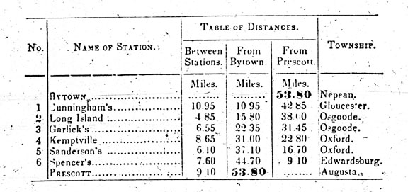
The second point is well situated to attack, the Traffic from Metcalfe and all the Northern sections of Osgoode—also from a large portion of Nepean, North Gower, and Goulborn. It is situated on the “nine mile road” in rear of Rossiter’s Tavern, (“Barton’s Corners”) from which it is distant about 2¾ miles, and is within a little over 2 miles of the Rideau Canal, at the Head of Long Island. The Station at Garlick’s will be likely to prove an advantageous one. It is less than a mile from Garlick’s wharf, on the Canal, and on the direct road from thence to John C. Bower’s store in the 3rd Concession of Osgqode—and distant from it about 2½ miles. A large portion of the business of Marlborough and North Gower, on the West, and of Osgoode, Mountain, and Winchester, on the East, will find its way to this Station. Amongst the Maps before you is one of Kemptville and its vicinity —showing the location of the Line with regard to the village. 33
The most suitable position for the Station, is on the East side of the Creek near by Mr. Barnes’ Saw Mill, being just half a mile from Adams’ Tavern. The ground is almost “ready-made” for Station purposes, and the main Line can be connected by a few hundred feet of Side Track with the navigable waters of the South Branch of the Rideau. The business to which the Railroad may look forward at this point, will be derived from the flourishing Township of Oxford, in which Kemptville is situated, and from Mountain and South Gower, East of the Line—whilst Maryborough, Montague, Wolford, and, other productive Townships further West, on the Rideau Canal, will here find a cash Market, at all seasons of the year, for their surplus produce, and a cheaper one than they have ever yet known wherein to purchase their supplies. The next point at which I have suggested the construction of a Way-Station is at Mr. Saunderson’s Farm, on the Ninth Concession, of Oxford—a little West of the “Johnston settlement.” It is but 4¾ miles from “Heck’s Corners,” and will be a convenient “rallying point” for the Settlers of the Northern portions of Augusta and Edwardsburgh and the Southern sections of Wolford, Oxford South Gower and Mountain. Spencer's Station will be situated 1.1-5 mile West of the Mills, on the new Macadamized Road leading to Prescott. From its close proximity to the "Front," there will probably be less business done here than at any other Station on the route. Characteristics of the Road
Distance.
The length, of the Line from the West end of McTaggart Street
(Bytown), directly above the Ottawa, to where it strikes the St.
Lawrence below Prescott, is 53.12 miles—being nearly 10 per34
cent, longer than an air line between these points; this increase of length is chiefly occasioned by the ‘detour’ necessary to reach Kemptville,—notwithstanding which the percentage of increase is small compared to many of the most important Roads in the United States, where the actual distances traversed often exceed air-lines between the Termini by from 30 to 60 per cent. The whole length of Rail upon your Road, measuring from the above named point in Bytown to Frazer’s wharf, within the Town of Prescott, will be 53.75 miles. Linear Features
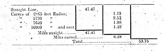
About 88 per cent of the above distance will be in straight lines, and, excepting close to the Termini, there will be no curves of less radius than 5730 feet; the least radius anywhere being 2865 feet. Summary of Tangents and Curves.
Gradients.
There is no gradient on the Route exceeding 30 feet to the
mile; and of planes of that degree of elevation there are in all but
4½ miles —seventy-five per cent of the whole Line being either
level or in inclines of less than twenty feet to the mile.35
Summary of Grades.
Level and under 11 feet to the mile,........... 25.73 miles. From 11 feet to 22 feet " " ........... 18.04 “ From 22 feet to 30 feet " " ............ 14.36 “ Total......................... 53.75 “ Attached to this Report is a detailed table of Grades, showing the number of Planes on the Route;—their lengths, elevations, and the order in which they occur. (Appendix “B”) With two exceptions, the public highways will, all cross the Track at “Grade”—the cheapest of any of the modes that must be resorted to for Railway “crossings.” The highway at Prescott must be passed underneath the Track, involving the construction of a viaduct of some considerable cost; and the Osgoode road, where cut by the Line at Cunningham’s in Gloucester, must be carried over the Railway by means of a bridge. In these Northern latitudes the labor of keeping the Track clear of snow during winter adds not a little to the ordinary expenses attending the maintenance of Railways. Roads having a North and South direction, as yours will, would, in this section of; the country, be especially subject to this disadvantage, the drifts being, almost universally, East and West. As an offset to this difficulty, however, your Road will present one very favorable feature; which is, that for more than two-thirds of its length it will stand above the surface of the ground, generally, not less than four feet when “ballasted up.” This will insure all that portion of the way from ever being seriously obstructed in the manner referred to, because the sweep of the wind over the elevated surface will be certain to keep it free from any inconvenient accumulation snow. At some points of the Line, especially in the Townships of Edwardsburgh and Oxford, it will be necessary to have recourse to temporary structures of wood, such as “Trestlework” and “Piling,” 36
to convey the Track across hollows where material for making embankments is not at hand, and through Swamps having deep coverings of vegetable soil unsuited to the formation of a Road-bed; such places can all be filled in and the permanent way completed by aid of the Locomotive and Rail-cars, long before the timber will have decayed. The great abundance of timber along the Route will admit of all work of the above description being constructed at minimum cost. Material for “Ballasting” will be somewhat difficult to be obtained in Gloucester and portions of Oxford— elsewhere throughout the Line it will be found either in the necessary excavations for the Road-bed, or in such close proximity to it as to allow of the cost of this branch of construction being kept within economical limits. Estimate
The Estimate has been prepared with care; the quantities of excavation and other items, coming under the general of “Grading,” having been ascertained by careful calculations and such prices affixed to them as should allow of a fair proportion of the payments being taken, by Contractors, in the Company’s stock at par. The great quantity of Tamarac, Cedar, Hemlock, and other suitable kinds of Timber, on, or in close contiguity to the Line should enable you to obtain all wooden materials at a low rate and, to a considerable extent, for Stock. I have estimated the Iron at the price at which it could now be obtained, and beg leave to remind you how important it is that early contracts be entered into for this essential article. The amount set down for Land-Damages may appear high, but I have estimated that item with a view to your securing more ground within, the Town limits of Bytown and Prescott, where, property will never be lower in value than at present, than your first requirements may demand. A want of forecast in providing room at the Termini to accommodate the inevitable growth of Railway business has proved an ultimate source of expense and inconvenience, to innumerable Companies. 37
Estimated cost of one mile of Superstructure
The system of Superstructure for which the above Estimate
is designed will be understood from the subjoined brief specification.
The Rail is to be of the “inverted T” pattern and to weigh sixty pounds to the yard. It is to rest on, and be firmly spiked to, cross-ties—which are to be laid thirty one inches apart from centre to centre. The ties to be of Tamarac or Cedar, seven by nine inches and seven and a half feet long. Wherever the road-bed can be ballasted previous to the Track being laid the ties will simply be bedded in the ballast—which will be of course sand or gravel—two feet in depth; but where, from the absence of such material, the Track will have to be laid at Sub-grade the ties will lie on two sills of Hemlock plank—ten by three-inches. The position of these “subsills” beneath the tie corresponding to that of the rails above it. The Rails are to be secured, where, they, join, by cast Iron chairs, of about twenty pounds weight. The width of Track for which my Estimates are intended is that known as the “Narrow Gauge,”—4 feet 8½ inches between the Rails. The subject of the Gauge,—one which has given rise to much discussion both on this continent and in Great Britain—is at present, I believe, engaging the attention of the Railway Committee of the House of Assembly. The Commercial advantages to which the narrow gauge, especially as regards Canada, can lay just claim, so far outweigh, in my judgment, the alleged—but not yet proven—mechanical superiority 38
of a wider track, that I feel satisfied it will be adopted as the gauge for this Province—and certainly nothing short of Legislative enactment to the contrary could induce me to recommend any other for your Road. Estimated Cost of Grading and otherwise completing
the Road-bed.
Per mile cost of 53¾ miles—say,......
£1,626 0 0
For the above sum, one-fifth of which should be payable in the Stock of the Company, at par, you can have a very perfect Road way,—completely drained, graded, and bridged,—including the purchase and fencing in of Lands. The estimate contemplates a single Track, with “sidings” at intervals of from five to nine miles. The cuts are to be twenty four feet wide on the bottom, and the embankments to finish fifteen feet on top. The Culverts and Bridge abutments are to be of permanent and durable Masonry, and the superstructure, of the Bridges of the most approved combinations of Wood and Iron. 39
The ballasting of the Road-bed, which will be a charge in addition to the above estimate of about £250 per mile, will be partly done during the progress of the grading, where material adapted to the purpose is at hand, elsewhere this portion of the work must remain incomplete until after the Road is in operation,—when, by aid of the Cars, it can be finished without preventing the legitimate business of the Railway from being carried on. Summary of Estimate of Construction.
The per mile cost, you will perceive, is but £3,628—Fourteen Thousand Five Hundred and Twelve Dollars,—embracing everything save the “Rolling Stock,” and falling very far short of the average cost of such undertakings on this Continent The State of Massachusetts, with a population of 865,000 souls, has now about 1200 miles of Railway, constructed at an average outlay of nearly Fifty Thousand Dollars per mile; and owing to which such has been the increase of wealth and prosperity within the State that, dating from the commencement of Railway enterprise, the city of Boston has more than doubled its population. The States of New York and Pennsylvania have each from 1000 to 1200 miles of Railway, of which the average cost may be taken 40
at Thirty-five Thousand Dollars per mile. In those, as in the New England States, prosperity seems to have kept pace with the Locomotive; for since the dawning of the Railway era we find that Towns and Villages have became Cities, whilst the Cities, that were Cities before, have increased in size a hundred fold. The following Table, showing, what has been the increase of population during the past twenty years in some of the leading Towns and cities in the Union, which are peculiarly under Railway influences, may serve to illustrate what are the practical results accruing from the facilities for social, and commercial intercourse presented by the Rail:— 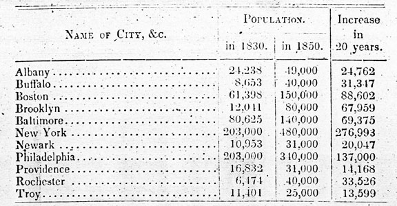
It is worthy of remark that in the majority of the instances here quoted, by far the larger portion of the increase took place in the ten years immediately preceding 1850. With a position unsurpassed by that of any inland Town in Canada, and endowed with an unrivalled water power, why should not Bytown, with its projected Railway completed, number, in fifteen years from now, its twenty thousand inhabitants? In addition to the sum above stated as necessary for the construction, of the road a further amount would still be required for its equipment with Locomotives and Cars—under this heading you will not be 41
able to do a paying business on a less outlay than
detailed in the subjoined :—
Estimate of Rolling Stock.
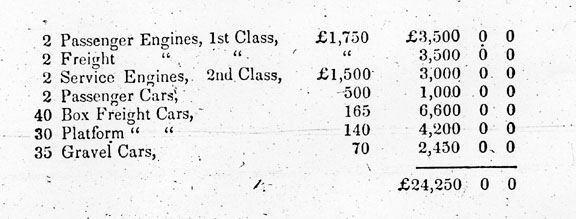
You may open your road with a smaller outfit,
but it is to be hoped that ere it has been six months in existence its requirements
will exceed rather than fall short of the above Estimate.
For the information of the inhabitants along the route, I have made an approximate Estimate of the amount which the construction of the road will cause to be expended, for labor and material, in each Township through which it passes. In round numbers it is as follows:- 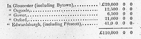
The immediate benefit to be derived to the farming
community, in the vicinity of the Line, from the expenditure amongst
them of such large sums of money, must be obvious to any thinking man—and
the prospect of so considerable an influx of capital should alone be
sufficient to silence the too general opposition of the Rate-payers
to consenting to their Municipalities taking Stock in the undertaking.
42
I have had the Line divided into Sections—averaging
in length about two miles each, and “Test-pits” have been sunk wherever
cuttings are required, so as to enable those desirous of contracting
for the work to judge correctly of the kind of material they will have
to deal with.
Statistics – Sources of Revenue – General
Remarks
Those familiar with the geography and physical characteristics of that Section of the Province known as the “Ottawa Country” cannot fail to have been impressed with the magnitude of its resources, whilst a glance at the map will be sufficient to show that, as regards that district, Bytown holds almost commanding position, warranting at no very far off date to render her the populous Capital of an immense extent of country, richly endowed with all the natural elements of Agricultural and Commercial prosperity. The portion of the valley of the Ottawa which, without looking to a too distant future, may be considered as likely to come under the influences of the Railway which is the subject of this Report embraces an area of 10,000 square miles; extending from Grenville, 58 miles below, to the head of “Les Allumettes” Island, 120 miles above Bytown; this merely supposes such of that region as is likely to be early amenable to complete civilization, without taking into account the more partial improvements certain to be going forward contemporaneously, on the yet unsurveyed lands beyond the extreme North Western limits above given. That Section of the River Ottawa, traversing as much of the above described territory as lies, below Bytown, affords an uninterrupted Steamboat navigation of close upon sixty miles—in which distance it receives seven large tributaries—the principal of which, the “Gatineau,” filling in one mile below the Town, is supposed to have a course of upwards of 100 miles in length, is ascertained to be 1000 feet wide at 200 miles from its mouth, and may be said to drain an area of 1200 square miles-a country abounding in 43
valuable timber, rich in Iron ore and other minerals
and possessing large tracts of land that can be made subservient to
the purposes of Agriculture.
North West from Bytown lies the vast region of the “Upper Ottawa,” displaying thriving settlements, on each side of the River, for a distance of 120 miles. This, like the Lower Ottawa, is also fed by many tributaries, some of them streams of very considerable magnitude. Beyond, and in the rear of the settlements are inexhaustible forests of Pine and other timber, and the soil generally as far as explored, is deemed well adapted for the support of an Agricultural population. At Bytown, the navigation of the River is intercepted by the “Chaudieres” Falls and Rapids; round which is a “portage” of eight miles—over a fine macadamized road, to the flourishing village of Aylmer. Thence there are 30 miles of Steamboat navigation to the “Chats” Rapids, at which point there occurs a “portage” of three miles, by Railway. From the "Chats" to “Portage du Fort—30 miles—is also navigable, and here, at 70 miles above Bytown and 200 miles from its junction with the St. Lawrence, below Montreal, we find commodious Steamboats plying on the spacious bosom of this noble River. Ascending further towards its still far distant sources, and interrupted but by one inconsiderable Rapid, there are not less than 90 miles of navigable water; reaching from the “Calumet” Falls, 7 miles above “Portage du Fort,” to the head of the “Deep River,” 103 miles above Bytown. Doubtless the time is at hand when the placid surface of those distant waters, over which, as yet, has only skimmed the frail canoe, will be ruffled by the paddle wheels of the busy Steamer, carrying into these almost unexplored regions the immense supplies annually required by the “Trapper,” the “Voyageur” and the “Lumberman”—those Canadian “Arabs”—whose numbers are now counted by thousands and whose unfixed abodes are in the ever-receding forests beyond. The streams above referred to, as tributary to the Ottawa— sectioned by frequent Falls and Rapids—are all peculiarly favorable for being turned to account for manufacturing purposes. The amount of Water-power that could thus be made available, even 44
within a moderate circuit of Bytown, is beyond
all calculation— whilst within the very precincts of the Town itself,
the main River, precipitated over the “Chaudiere” Falls; presents a
power, almost ready made, to the extent and capacity of the whole volume
of this mighty stream. In this instance alone Nature, anticipating Art,
has done more towards constructing a motive power for machinery than
has been effected at an outlry [should be "outlay"] of hundreds of thousands
of dollars by the enterprising men to whom Lowell, Lawrence, and Hadley,
and other great manufacturing towns of New England, owe their existence.
The population of the “Ottawa Country,” as above laid down, may be taken at 65,000—in the following proportion to each territorial division:— County of Ottawa,........................................... 18,000 “ Prescott and Russel, (in part)............... 5,000 “ Carleton,............................................. 22,000 “ Lanark and Renfrew (in part)............. 23,000 Town of Bytown.............................................. 7,000 Settlers on unsurveyed Lands— say,……......... 5,000 Floating Population in Lumber region,—say.......... 5,000 85,000 That portion of the valley of the St. Lawrence
through which the Line is located, consisting of the County of Grenville,
contains about 20,000 inhabitants; so that there is a total present
population of 105,000, to whose Industry and requirements the projected
Railway would have to look for its support. Of this number probably 65,000
would contribute to the "through business, and 40,000 to the “way-traffic”
of the Road. Even with this population and the known fertility and resources
of the Country, the enterprise cannot prove otherwise than a safe
one to those embarking, in it: whilst counting on the rapid increase certain
to take place under Railway impulses (unless yours should prove an exception
to all similar undertakings,) and on the greatly enhanced value of real
estate, throughout the length and breadth of the circum-jacent district,
it cannot fail, within a brief period from its completion, to be
a most remunerative one.
45
I have already (page 40) quoted some instances
of the amazing growth of towns, under the fostering influence of Railways,
in the neighboring States: not one of the inland towns or cities there
cited possesses natural advantages equal to those with which Bytown
is so liberally endowed; nor is any one of them surrounded by a territory
of greater capabilities than the Counties of Carleton and Grenville.
I refer you to Appendix C for details of
population, assessed value of property, &c., &c., on, and in
connexion with the Route.
To render apparent what must be the advantages derivable to the “Ottawa Country” and the Townships on either side of the line of road from the opening of such a channel of communication with the avenues to the sea-board, I must again point to the Map of this section of Canada. The Road will connect Bytown,—the Capital of sixty miles of country below and one hundred and fifty miles above it,—with the River St. Lawrence, at the most favorable point possible, to wit;— The foot of Lake navigation, and where a Ferry of scarce a mile in width, gives a connection with the Ogdensburgh Rail, and, through it, an unbroken communication with the Cities of New York, Boston and Montreal, and the entire chain of Railroads in the New England States, and the Southern section of the State of New York. From present appearances it is, at least, probable that the “Main Trunk Line of Canada,” will be laid not very far from the St. Lawrence. I would consider this as advantageous to your interests, because all the traffic, whether passenger or freight, destined for Montreal:—from the Ottawa—and which would be immense—would then have to pass-over three fourths, of your Rail and would contribute to your revenue nearly as much as so much “through” business. You will thus have a choice of Markets: by means
of a well arranged system of “Ferriage” at Prescott, you can have access
throughout the year to the two best that this Continent can boast —Boston
and New York—and, awaiting the construction of the Trunk Road, you
will be able to reach Montreal by Rail, via Rouse’s Point and St. John’s,
at all seasons.
46
The following Table shows the distance from Bytown to the principal Cities and Towns where the business of her Merchants is likely to call them, and the time it will take to reach them :— 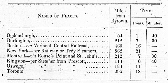
With your existing modes of travelling, it requires as much time to reach the St. Lawrence, at Montreal or Prescott, as with a Railway from Bytown to Prescott, would be sufficient to carry you halfway to New York, or three fourths of the way to Boston. The journey to Kingston, which now occupies twenty-four hours through the tedious windings of the Rideau Canal, could then be accomplished in less than one third of the time, and, in the same way—and time the “Rome and Cape Vincent” Railroad Terminus could also be reached. In the summer trip from Bytown to Montreal, a saving in time of five hours could be affected by taking the Circuitous Railway Route; whilst the winter journey could be performed in less time by at least eight hours than the best “sleighing” could admit of. The manifold advantages which the commercial and travelling community, generally, throughout your section of the country would derive from these increased facilities of intercourse with the larger towns of Canada, and the Atlantic Cities of the Union need no comment. Railway-Traffic may generally be classed under three heads. 1. Through Freight business. 2. Way do. do. 3. Passenger do. 47
I will touch as briefly as possible on what I consider
to be the legitimate expectations of your undertaking from each of the above
sources.
Taking the cost of construction and equipment at £220,000, and the expenses of operating and maintaining the Road at 50 per cent of the gross earnings—a large proportion in view of its favorable characteristics—it would be necessary to do a business to the amount of £26,400 per annum, before six per cent on their investments could be divided amongst the Shareholders. If for the first two years from the completion of the Road; its earnings should only be sufficient to meet current expenses, and the interest on whatever amount of bonds you may have to issue, the Stockholders would not, I think, under those circumstances, have any reason to be apprehensive of the successful results of their undertaking, because the certain increase of trade, under its influences, would ensure its becoming, from that time forward, a remunerative investment. That an amount of business sufficient to defray expenses and interest would accrue to the Road at once on its coming into operation, can hardly be doubted, and I incline to believe, even, that the earnings of the second year would be nearly, if not quite, equal to the sum required for expenses, interest, and a six per cent dividend. I predicate my Estimate of the Through Business,
to be looked forward to, mainly on the great Staple of the Ottawa,— Lumber. In the article of “Sawed Lumber,” a very large trade has, within a short period, sprung up between the Ottawa country and some parts of the United States. The exportations last year reached as high as twenty millions of feet—board measure. The Saw Mills at present in operation on the Ottawa, and its tributaries, are capable of manufacturing five times that quantity—and yet the water powers of that region are scarcely more than “tapped.” The demand in the United States for this article of commerce, is yearly increasing, while the means of supply within her own Territories are as rapidly on the decline. The transportation from Bytown is now effected by water, and the time required to reach Lake Champlain, through the circuitous route of the Chambly Canal, about 48
ten days. The Lumber required for the Eastern Market, is then transferred to the Rail at Burlington, that for the South proceeds by Canal to Troy. With your Railway in operation, Sawed Lumber could be laid down at almost any point in Vermont, New Hampshire or Massachusetts, in four days from Bytown, with but one trans-shipment, (at Prescott.) Southern New York is fast stretching out her iron arms to connect with the Ogdensburgh road at Rouse’s Point. With this junction effected, your Lumber could also be delivered in Troy or Albany in half the time it now takes to reach Whitehall. The tariff on sawed lumber over the Ogdensburgh Road is $2.50 per M. feet, board measure, allowing for your Road $1.50, including the trans-shipment at Prescott, would make the through freight from Bytown to Lake Champlain $4 per 1000 feet, at which rate, in the article of Seasoned Clear Lumber at least, you could very well, compete with the water route. The facilities for bringing Lumber to the St. Lawrence should open to you other channels for this branch of trade than those to which it is now confined. Oswego would be likely to take large quantities, to be sent through the Erie Canal for the supply of the numberless flourishing towns along that great, commercial highway. I deem it not imposssible, even, that an important trade in this line might be established with the towns upon Lake Erie, and even further West. The Schooners bearing the products of the Western States to the Ogdensburgh Railroad, have generally to return in “ballast”—and are therefore glad to get any kind of heavy freight to take back at almost any rates that will pay cost. In this way the sand stone from the Potsdam quarries, in the vicinity of the Ogdensburgh Road, is sent in such quantities to Cleveland, Chicago and elsewhere on the upper Lakes for flagging, as to form quite an important item of way-trade to the Railway. This stone has been carried to Cleveland, in its manufactured state, for 75 cents the ton. Why might not the Lumber of the Ottawa be sent in the same way, to contribute to the growth of these ever increasing cities of the Far West? In view of all these probabilities of a vast and rapid increase in this branch of Commerce, it is hardly presuming too much to suppose that the annual exports to the United States will in three years from now have reached to forty millions feet board measure; and assuming that but one half of this quantity—twenty millions—is 49
carried by rail to the St. Lawrence, at the rate of $1.25 per 1000 feet— your road would reap from this source an income of £6250 10s. From the various and numerous other shaped articles in wood, such as Lath, Shingle, Staves, Hoops, &c., I would assume an income of £1500 — making the whole revenue from the products of the forest, amount to £7750. The country North and North West of Bytown, will have a surplus produce to send out, consisting of the coarser kinds of grain — Rye, Barley, Oats, &c., also potatoes in large quantities, Ashes, and Cattle. Judging from the present products of the country, it is safe to count on £1500, as the amount of freight on such exports as the, above; and which, with the revenue from Lumber, &c., make up a sum of £9250 for the whole “through freight” receipts, on outward bound articles. Your imports will consist of Provisions, such as Flour, Pork, &c., for the support of the population engaged in the Lumber trade, whose numbers will average annually nearly 11,000 — and whose consumption has been estimated at 30,000 barrels of Flour— 27,000 barrels of Pork — 2,700 chests Tea — besides Spirits, Clothing, Tobacco, &c. Nearly all the Pork, and much of the Flour, is brought from abroad — either from the United Stales or from the Western sections of Canada, and would be certain to reach Bytown by way of Rail from Prescott. Those imports, with all their accessories, for the support of the non-producing population, may be set down as adding £1500 to the receipts of your road. Many of the principal merchants of Toronto, Hamilton, and other rising Towns in Western Canada, are beginning to import their goods by way of Boston, bringing them through, in “Bond,” over the Ogdensburgh road. The quantity of “Debenture Goods” that have been brought, and are now under contract to come, over that road, is enormous. With but one break in the Railway connection between them and Boston, or New York, the merchants of Bytown will assuredly find themselves equally in a condition with their brethren in the West to act as their own importers. It is not unreasonable to expect that, by the time the road could be opened to the public the demands of the Ottawa Country for British and Foreign 50
Goods would amount to 2000 tons, on which you would, receive £1000. There are forwarding Houses in Boston now making contracts with merchants in Toronto, and elsewhere in Western Canada, to deliver goods direct from England at £5 per ton—or if brought per mail Steamers, as “Express Goods,” for £8 per ton, to be delivered in Toronto in 16 days from Liverpool. The heavier articles, of Canadian or American manufacture, such as Stoves and other Castings—Iron, Nails, Plaster, Salt, Machinery, Furniture, &c., &c., will form a large source of income, which I venture to put down at £300. From Imports, therefore, you should derive a revenue of £3,300, making a gross amount of receipts on “through business” of £12,550. For the number and capacity of Saw Mills now in operation on the Ottawa and its tributaries, and the number of hands employed in working them, see Appendix D. Way Business. The Way-Trade to which your road may look forward, will be one of its chief sources of profit. The demand in the Eastern States for all description of produce for which the soil and climate of this Section of the Country are best adapted, such as Oats, Potatoes, &c., &e., is yearly on the increase. The farming community on and contiguous to the proposed line of Railway, have already sensibly felt the benefits of the market created by the Ogdensburgh Railroad. Appended to this Report you will find a comparative statement (vide Appendix E.) of Entries, from Canada, at the Ogdensburgh Custom House, in the year 1850, and the half year ending 30th June, 1851. The increase there shewn is enormous, but does not convey a perfect idea of what this trade has Been, because very large quantities of grain and potatoes, owing to the want of facilities —since perfected—for crossing Lake Champlain, at Rouse's Point, were sent round by water to Burlington. I know one trader who shipped 20,000 bushels in this way. The nucleus of a trade has thus been established, which, with Railway conveniences of your own, might be nurtured into one of sufficient magnitude to support 51
a Railroad, unaided from any other source. The pioneers in this trade have been a few stray Americans, from Boston and the vicinity, who, not deterred by bad roads, and, it must be confessed, rather uninviting appearance of the country immediately in rear of Prescott, have penetrated as far North, perhaps, as Kempville; their transactions, last winter, may have reached to the extent of 70,000 bushels, chiefly Potatoes and Oats, picked up in small lots; the mere “waifs” of the products of the country. In the apparently insignificant article of Eggs, I find, in the Canadian entries at Ogdensburgh, against one hundred and forty dozen in 1850, upwards of fifteen thousand dozen in the first six months of 1851. The produce in potatoes, oats; barley, maize, &c., of the Counties of Carleton and Grenville, and such parts of Lanark, Renfrew, Russell and Dundas, as would contribute to the way-trade of the road, amounted last year to nearly 1,225,000 bushels; with a certain market to depend upon, there can be no doubt but that a surplus quantity equal to the above would be raised, and disposed of to foreign purchasers. From the products of the field, therefore, with those of the dairy and the poultry yard, which will be attracted to the road at all the way-stations—you may count upon a revenue of £6000. At two points convenient to the road, the Rideau Canal presents fine, but neglected, water power. Under the new state of things, consequent on railway influences, these will, doubtless, be made subservient to manufacturing purposes, and through their agency a portion of the products of the forest will be shaped into marketable articles and sent over the Railway, from the nearest station, to find a ready sale on the banks of' the St. Lawrence. Another portion of the products will be disposed of in the forms of cord wood, railway ties, bark, ashes, &c., and the whole trade from this source—the forest—should be of sufficient magnitude to add £300 to your receipts—the imports of “store goods” for Kemptville and to be dispersed throughout the villages right and left of the line, with all the heavier articles of importation, enumerated under “through business,” may be put down as likely to yield you £800 more. You would thus derive from the way-business of your road a revenue of £7600 52
That I have not overrated the probable, value of this portion of your prospective trade, I feel convinced, from the results that I know to have taken place on the Ogdensburgh Railway—a work constructed through a country of attributes strikingly similar to those of the country between the Ottawa and the St. Lawrence, on the line of your road—abounding with lumber and with great agricultural and manufacturing resources, as yet scarcely developed. The local traffic on that road has surpassed the most sanguine expectations of its projectors, and large sums of money are now being expended to increase the accommodations at way stations. The sum I have put down as likely to accrue to your annual revenue from local traffic hardly amounts to two months average receipts from way-business on the Ogdensburgh road. There are two stations on that route, those of Potsdam and Madrid, which each do as much business annually, as I have assumed for your whole income from local sources. The Townships in which the Stations referred to are situated, and those flanking them, are perhaps more populous than your best Townships by about one third, but possess no natural advantages over yours, either in an agricultural or commercial point of view. At other stations along that road, situated in Townships inferior in population and fertility to the average of yours, I find the monthly receipts running from £200 to £400—exclusive of passenger business. With such facts before me, I feel satisfied that I am –within bounds in estimating your second year's income from way-business at £7600 Passenger Business.
The data for arriving at a fair estimate of the number of passengers likely to pass over your road annually, are necessarily imperfect—owing to so large a proportion of the present travel being accomplished by means of private conveyances. Taking into account the numbers that now travel to and from Bytown, and its surrounding country, via the Ottawa, to Montreal, 53
and the Rideau Canal, to Kingston—during the season of navigation—and by stages or private or hired conveyances in winter, and between Bytown and Prescott at all seasons, coupled with the rapidly increasing intercourse with the United States, and a newly created desire amongst the home community to "see the world"—a desire invariably attendant on Railway conveniences for travelling—I do not think I estimate too high in assuming that in three years from now, there will be travel enough between the Ottawa country and the outer world, to afford 12 passengers daily—each way—over the road bringing into your coffers an annual amount of, say.................. ..................... £3000 0 0 to which I would add for " way passengers".. 1700 0 0 which only premises, under the latter heading, the average receipts per month, at each station, at about. £18. At the stations above quoted, on the Ogdensburgh road, I find that the tickets purchased at the stations, by the travellers outward bound, only amount to from forty to one hundred pounds per month. Recapitulation of Items of Revenue,
as. above detailed, stands as follows:—
54
will, I think, admit that the above estimate of revenue is predicated on reasonable grounds; most of the items assumed being based on the present capabilities of the country, without allowing for the certain increase of population, and consequent enlarged demands of trade, which must annually take place—Railway or no Railway. The indirect benefits to the whole region interested in this project would very far surpass in importance the most favorable estimate of direct results—as above touched upon. Its accomplishment would place Bytown in a position second in commercial importance to that, of no town in Upper Canada :—Prescott would at once be elevated into a place of consideration, as the trans-shipping point and depot of a large and growing trade, whilst the wide extent of country beyond the Northern terminus, and on either side of the line, would feel the vivifying effects of Railway communication in the enhanced value of property, in the stimulus given to its agricultural and manufacturing capabilities, by the opening of new markets, and the influx of foreign capital; and lastly, in the cheap and speedy facilities for travelling, which, whilst inviting the stranger to visit the country of the Ottawa, will place within reach of the many—among its inhabitants—the means of visiting, in turn, the more advanced and flourishing sections of the Province, and the neighboring States. By taking advantage of the remaining portion of the present season, in making a vigorous commencement of the work—to wit—in clearing the whole of the wood-land portions of the route, and entering on the grading at the points where the excavations will be of the greatest magnitude—the Bytown and Prescott Railway can be ushered into existence, as a public highway, in May, 1853,—and in concluding this report, I would express an earnest hope that no untoward event may intervene to mar the timely completion of a project fraught with benefits to, so important—though hitherto not too well known—a portion of this noble Province—a project, the accomplishment of which, I believe to be within your grasp; for, after all, it is but a pigmy one compared to many that might be instanced on this continent—successfully achieved, in the face of truly great difficulties, by communities possessed, comparatively speaking, of 55
no more extensive resources—and with no higher interests at stake —than your own—proving to the world how great obstacles can be vanquished, and how much public good compassed by well directed energy and union. I remain,
Gentlemen,
Your obedient servant,
W. SHANLY.
|
Click here to see the Appendices
![]()
Last updated on 3 January 2005.