Nothing
like a fine fall day to
explore local railway
history and archaeology. Three CRHA Kingston Division members, George
Dillon,
Bill Thomson and I, David Page, set off on Wednesday 07 October 2009 to
see
what they could find of the Bay of Quinte Railway(BQR) line from Yarker
to Tweed (see brief history of the
BQR at the end of this
article). This section of the BQR would be of most interest to
Kingston-area
members because it was part of Kingston-Tweed connection providing
passenger
service by successor CNR until 1925, and not abandoned until 1941.
George had seen some of the features
of the line some 20
years ago, and spent part of his childhood in Tweed.
His guidance, along with old topographical maps showing the abandoned
line,
enabled us three to spot and record the incredible amount of physical
archaeology still visible nearly 70 years after railway operations had
ceased.
We started our search in Yarker, at Sidings St.,
and walked across the CNoR
“new bridge”, now part of a railway trail. From this bridge, on the
north side,
one can see an abutment in the Napanee River
from the original
BQR line to Harrowsmith and Sydenham. This lines up with stonework just
visible
in the brush alongside County Road (CR) #6, northbound, at the edge of
the village
of Yarker. The
BQR old bridge track was one
leg of the mainline wye at Yarker, the other two heading north to Enterprise, Tamworth and Tweed,
and west to Napanee.
.
BQR bridge abutment at Yarker.
Bill Thomson
photo.
Next stop on the way north on CR#6,
we wanted to see if
the old topo maps were correct in showing the BQR alignment touching
the
roadway at the bridge over the Napanee River at its source, Camden
Lake. Sure
enough it did not take long to spot railway-type stonework adjacent to
the
current road bridge, with a short stretch of telltale gravel pathway
leading up
to it. Carrying on to the village
of Enterprise, we
located
the station platform in a field just off West St., south of the main
street. The
station itself has been gone for some time.
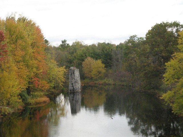
The BQR high-level bridge over the
current CPR Belleville
sub was made necessary by the latter’s construction in 1913. It and its
remains
are situated just NW of Enterprise, and are a well-known artefact of
the BQR.
The closest access to this site is at a dirt road level crossing of the
CPR,
about ¼ mile to the east. The south abutment of the abandoned
bridge is just
visible from the CP crossing. We walked to the site and were interested
to note
that the abutments were of concrete and were badly eroded by time and
the
elements. In addition the south abutment is about six feet below the
BQR grade
meaning that there must have been a steel or other footing in place to
fill in
this gap and support the bridge span. The gap on the north side is even
greater, perhaps 12 feet. A photo taken in 1958 in “Lost Horizons”
shows the
same relative heights, but without all the brush that has grown up in a
half-century.
BQR bridge abutments at CP Belleville sub
crossing.
Dave Page
photo
Continuing on CR nos. 14 and 4 we
enter Tamworth from the
south, alongside the Salmon River.
New housing
and landscaping have obliterated all signs of the BQR right-of way
where the
line swept up to the northwest and crossed the river. Once in Tamworth,
we made a hard left at the main intersection and went down Concession St. South. About a ¼ mi along, there was the
station in
alarming pink(probably faded red) on the left, with a large,
railway-style “TAMWORTH” sign
prominently displayed. The station is the
standard BQR design, with a two-storey main section with a full-height
bay
window, extending into a single-storey freight/express shed at one end.
The
building has become a house and still has the railway right of way
(r-o-w) in
front.
Tamworth station, Bill Thomson in
foreground, George Dillon further back.
Dave Page
photo
Next on CR #4 and Hy 41 to
Erinsville, pleasantly situated
on Beaver
Lake. The
station is very easy to spot:
it is in the lakefront park and has been white-washed completely. It is
not
occupied. The railway r-o-w is visible as it curves past the station
and off to
the east.
A further 8 km along CR #13 brought
us to Marlbank, a
former high-quality portland cement mining site and important customer
of the
BQR. The station in Marlbank, in the SW corner of the village, is now a
well
cared-for house, still with platform and baggage extension in place.
The owner
told us it is in good condition despite having been built in 1880s. The
railway
r-o-w is also well maintained, and is technically walkable back to
Erinsville,
although farmers have erected gates along the way to deter ATV
operators who
have damaged property.
Marlbank station, with r-o-w (and Bill
Thomson) in foreground.
Dave Page photo
On up Marlbank Rd toward Tweed
we nearly zoomed on past Stoco station well hidden by trees, on the
right, just
past the (Moira) East Channel bridge (the present road is on the
railway
r-o-w). This station, too, is a
well-maintained house, of the same BQR standard design, but reversed,
with the
baggage section on the left. The owner told us that hers was the only
station
that still had the original room configuration inside.
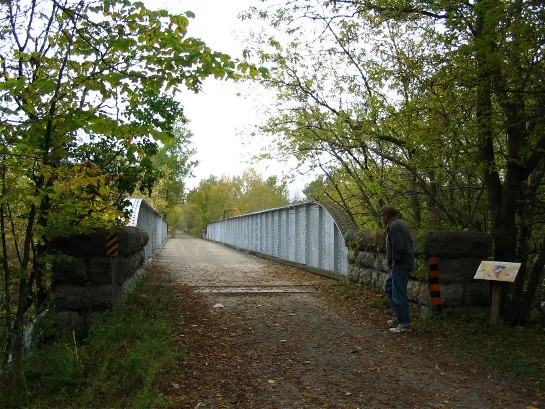
The last destination was Tweed
itself. There is very little visible evidence of Tweed’s railway
history,
except for the CP Havelock sub railway trail at each end of River St.,
and the
sturdy CP plate-girder, two-span bridge over the Moira at the east end.
CP Havelock
sub bridge at Tweed.
Sign on right refers to chipmunks, not railway history! George Dillon
in
foreground.
Dave Page photo
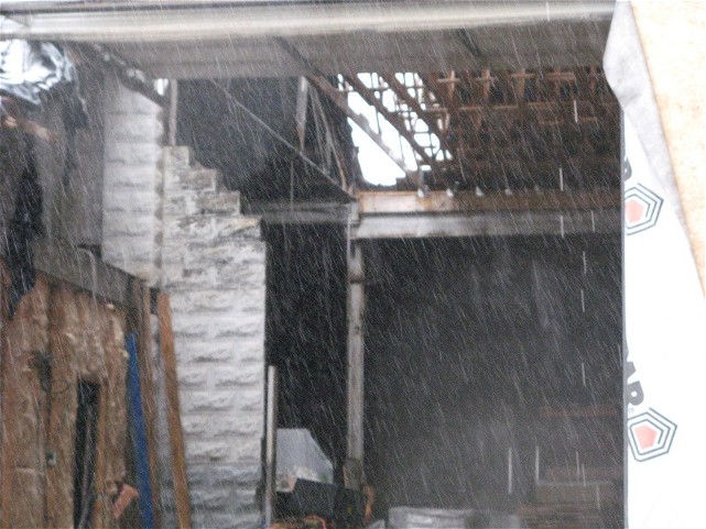
BUT there
is one
BQR artefact left: well hidden, and, had George not remembered its
location, it
certainly would have been missed. The two-stall BQR enginehouse has
been
incorporated into a much-larger lumber warehouse, essentially intact.
By good
fortune the main door of the warehouse was open and we could see the
enginehouse clearly. Its stone (or early concrete block) walls and
steel beams
are all visible and quite impressive. What a find!
The site is located in the SW corner of Tweed, just where the CPR and BQR crossed River St..
The Tweed map in “Lost Horizons”
identifies the enginehouse
as legend item no.3.
BQR
two-stall enginehouse at Tweed,
inside a
lumber warehouse. Note stone wall and steel trusses centre left, rear.
Pardon
the sudden rain squall!
Bill Thomson photo
After a brief Timmie’s lunch we headed back home,
satisfied that it had been a good day of exploration and discovery. It
is too
bad that none of the heritage artefacts that we saw are identified for
others
to enjoy as well.
Brief History of
the Bay
of Quinte Railway(BQR)
The BQR was a
creation of the Rathbun family business empire centred in Deseronto ON.
The Rathbuns needed transportation services for their many industrial
activities,
including cement, mining, lumbering and manufacturing, and so
incorporated the
BQR and a steamship company to fill this need. The BQR’s first line was
a short
connection to the GTR at Deseronto Jct., and this was opened shortly
after
incorporation in 1881. With the Napanee, Tamworth and Quebec Rly.
under BQR control, lines from
Napanee to Yarker and Tamworth were opened in 1884, and in 1889 on to Tweed and also east to Harrowsmith. The latter
provided a
connection with the K&P, and, in turn, resulted in running rights
into Kingston.
Subsequent
expansions of the BQR included Napanee to Deseronto direct, on
northward from
Tweed to Bannockburn,
and eastward to Sydenham. This filled out the extent of this small
development
railway. Decline of the Rathbun empire began in the first decade of the
20th
century and with it, the BQR. In 1914 it became part of the CNoR who
was
building their ill-fated transcontinental line through some of the same
territory. The BQR “network” unraveled as quickly as it had been built,
with
the original Deseronto Jct line being abandoned in
1906, and passenger service from Tweed to Kingston
ceasing in 1925.
The Tweed to Bannockburn
section was abandoned in the same year. Tweed to Yarker section was closed by then-owner
CNR in
1941. The final piece of the BQR, Deseronto to Napanee, was abandoned
in 1986.
Other than the
remaining archaeology described in the main article above, BQR
artefacts are
still visible in the form of station buildings, bridge abutments and
embankments, scattered from Sydenham to Deseronto.
Kingston, ON,
15 October 2009
Kingston
Rail