Wanderings of a Railfan Aviator
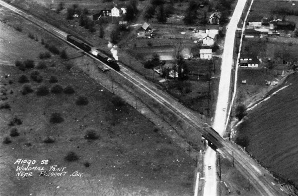
Royal Canadian Air Force Sergeant Diller woke up early on May1 7, 1929, and looked out of his window. The weather was bright but hazy with a 20 mph south west wind. It was a perfect day to do some aerial train chasing. Aerial photography was still in its infancy, having been started just after the First World War using military aircraft with a camera fastened to the gun mount. Sergeant Diller was a camera operator and he met his pilot, Flying Officer Emery at Ottawa (Rockcliffe, I presume) and they soon took off and headed for Brockville, Ontario. The first part of the mission was to run a line going west from Brockville taking overlapping vertical photographs. This recorded the junction area at Lyn where the former Brockville, Westport and Sault Ste. Marie railway had branched away from the former Grand Trunk main line now known as the Kingston subdivision. The connection between the two lines at Lyn had been completed in 1921, eight years earlier but the abandoned route of the BW&SSM from Lyn to Brockville can be clearly seen in the photos. The second part of the mission was, to me, more interesting because Flying Officer Emery and Sergeant Diller were to fly along the St. Lawrence River taking oblique photos. From the photos taken it is quite evident that at least one of the crew were interested in railways. Having photographed the then extensive Canadian National installations at Brockville the crew flew a couple of times around the Brockville Insane Asylum and then made their way to Prescott where they caught a CP freight train entering the yard. They then flew alongside the Canadian National main line to Cornwall where they photographed the waterfront and then went on to Valleyfield. They next flew across the centre of Montreal and reviewed progress on the construction of the Jacques Cartier Bridge. The final shots show the dirigible mooring mast at St. Hubert. They flew back over the centre of Montreal and took a few more shots before coming home. Whether or not Sergeant Diller was a railfan, he has preserved for us an interesting record of a railway which has changed greatly in the 72 years since they were taken. I would like to thank Phil Jago and Steve Hunter for their considerable help in the writing the captions . The aerial photographs (all pictures, except the second one) May 17,1929 Her Majesty the Queen in Right of Canada, reproduced from the collection of the National Air Photo Library with permission of National Resources Canada. 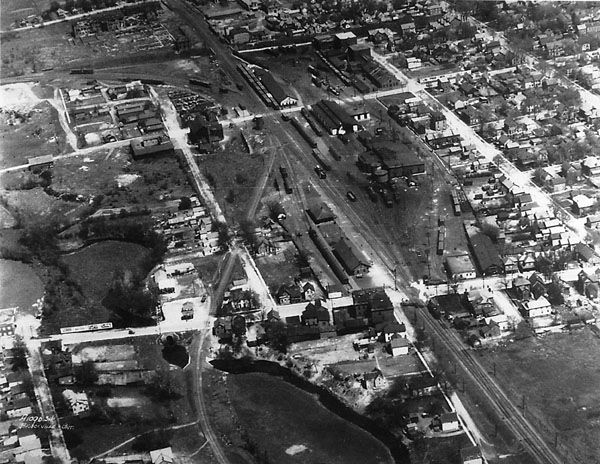
(A1090.34). This is a view of the CN station and yard at Brockville looking east with the CN main line running from top to bottom The CP Brockville subdivision runs into the station from the top left hand corner. The CP line under the CN and the town can clearly be seen at the top left. The CP Brockville Loop line runs from a connection down to the bottom centre. There are two prominent crossings at grade - William Street is towards the top of the picture while Perth Street is lower down close to the station. Gates were installed at William Street in 1910 and train movements on both CN and CP were protected by a watchman until the overpass was built in 1959. Gates were installed at Perth Street in 1918, operated by watchmen. Automatic operation was authorized in 1965 although the watchmen were retained until September 1975. In the winter of 1970/71, an engine movement derailed on an ice-filled frog adjacent to the gate tower. The units came off the track, crashed into the gate tower, knocking it over. It was heated by an oil-space heater which exploded. They pulled out the tower man but he died subsequently from the burns. The next day, the crossing signals were being activated by a watchman via a simple knife-type switch hooked up to an adjacent line pole. The engine terminal was knocked out until repairs to the track could take place. The tower was replaced several months later by a new tower which had electricity and electric heat - the old one used kerosene lamps. On a quiet day at the crossing when the tower windows were open, you could hear a bell sound in the tower when a train entered the block. This alerted the watchman to drop the gates. 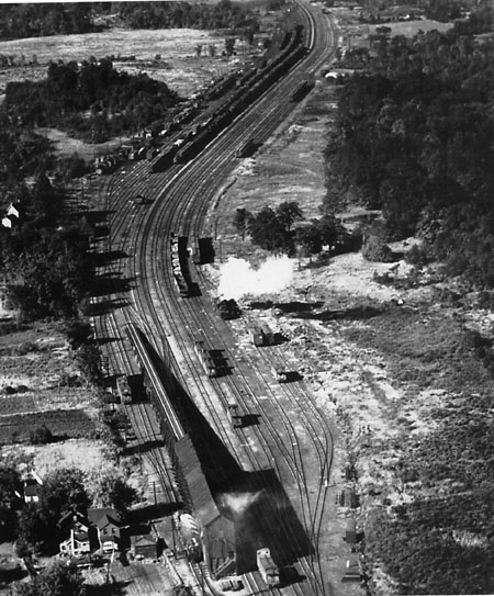
(Public Archives photo PA-203944 - Colin J. Churcher collection). This view of Brockville was NOT captured by our railfan aviators. It was taken from a position very close to the previous one in the late-1940s. It shows Brockville Manitoba Yards looking west. Prominent in this view is the coal trestle which was used to coal locomotives - one can be seen in the bottom of the picture taking coal. The tracks up the incline to the trestle were quite steep and the yard engine, usually an 0-8-0, had to take a run at it. On August 10,1910, two heavily loaded coal cars broke away from a string of cars being pushed into position. They crashed through the east end of the building and fell to the ground 60 feet below. The main line was blocked with coal and debris. A yard man standing on one of the cars, giving signals to the engineer, narrowly escaped being caught in the wreck. He saved his life by jumping. The large number of cabooses visible is clear testament to the amount of work done out of this terminal in those days. 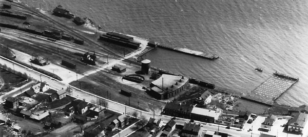
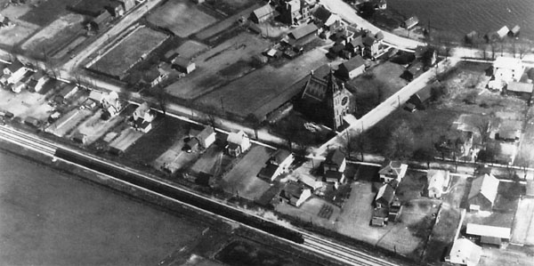
(A1091.5) - The caption for this view is "Church at Iroquoise (sic) Ont. This is the picture that has me convinced that the aircrew were railfans. To me it is a good view of a westbound train on the CN main line with an interesting church in the background! Several pictures were taken of this train and the aircraft must have circled it several times. I wonder what the train crew thought when they realized they were being buzzed by a military plane? 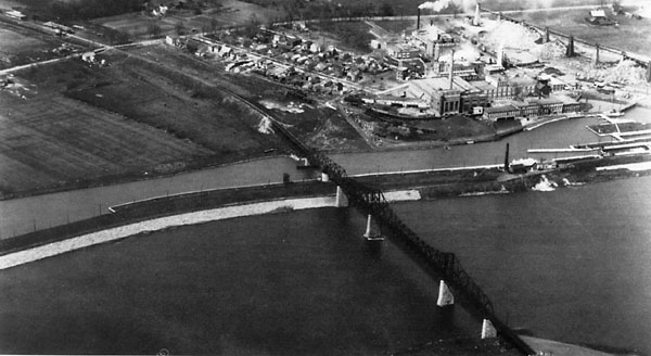
(A1091.25) - This is an excellent view of the Ottawa and New York Railway (New York Central) bridge over the north channel of the St. Lawrence River at Cornwall. At the bottom of the picture is Cornwall Island and the Cornwall Canal is in the centre with the railway swing bridge clearly visible. The wall of the Canal collapsed in 1908 and the swing bridge fell down and the NYC, which had just taken over the O&NY, was forced to bring in a temporary span to reopen the line as quickly as possible. The NYC Cornwall station and water tank can be seen in the top left side and there is a streetcar in the yard waiting until it is time for its next trip into town. The paper mill is prominent and there can also be seen a line which ran under the NYC trestle and along the Canal for a short distance to the west (left). The bridge was planked over in 1934 and access roads were built so that the infrequent trains could share this bridge, as well as that over the south channel, with road vehicles. The NYC service from Cornwall to Ottawa was abandoned in early 1957 and the bridge torn down in 1962 as part of the construction of the St. Lawrence Seaway. 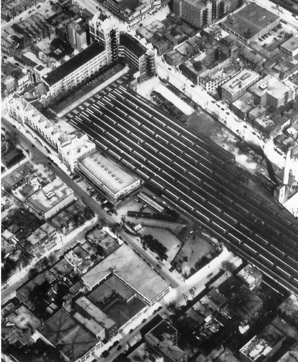
(A1091.46) -This is an aerial view of the CPR Windsor Station and headquarters building in Montreal, Quebec. To the left of the main station can be seen the mail and express terminal with a couple of sidings where cars were placed for loading and unloading, with at least two cars are visible in this picture. These sidings were removed likely in the 1940s. 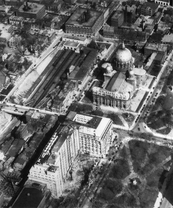
(A1091.75) -This shows the CN Tunnel Terminal in Montreal, which was opened for regular traffic by the Canadian Northern Railway on October 21,1918, and only served the Mount Royal Tunnel line. In 1943, CN's Central Station was opened on the site to the south of Dorchester Boulevard. The open area north of Dorchester Boulevard (lower left) was covered over by Place Ville Marie in the early-1960s. Under construction is the Sun Life Insurance building in the foreground. To the south of the Sun Life Building is the Mary Queen of the World Catholic Church. 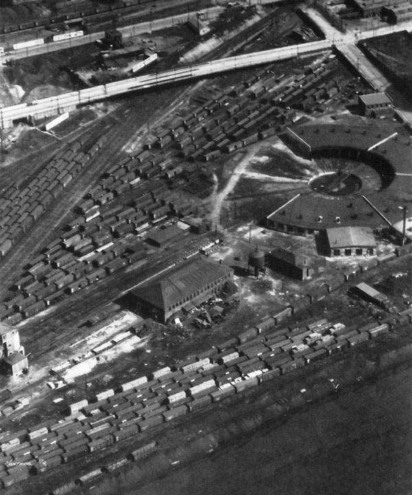
(A1091.70) - This shows the CPR roundhouse at Hochelaga in east-end Montreal. The roundhouse has 24 stalls and the ash plant and sand facility can be seen towards the bottom left.Bytown Railway Society, Branchline, March 2002 |